欢迎访问作物学报,今天是
作物学报 ›› 2021, Vol. 47 ›› Issue (9): 1816-1823.doi: 10.3724/SP.J.1006.2021.04211
张建1( ), 谢田晋1, 尉晓楠1, 王宗铠2, 刘崇涛2, 周广生2, 汪波2,*()
ZHANG Jian1(), XIE Tian-Jin1, WEI Xiao-Nan1, WANG Zong-Kai2, LIU Chong-Tao2, ZHOU Guang-Sheng2, WANG Bo2,*()
摘要:
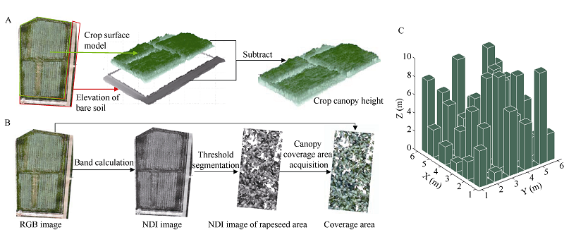
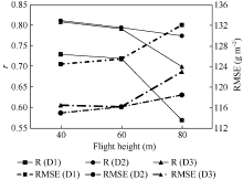
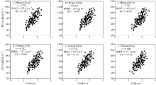
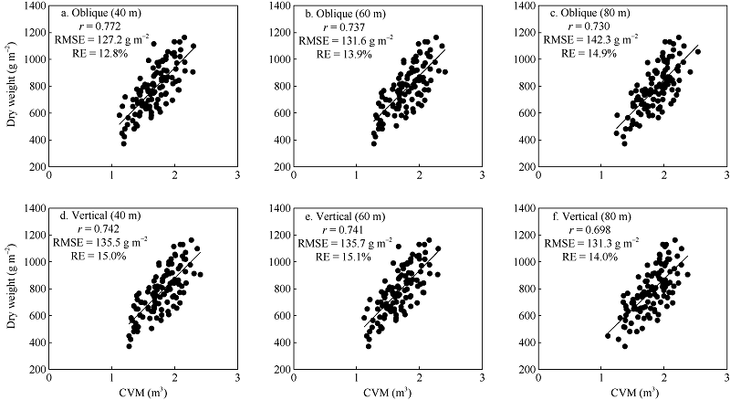
旨在探索并评估一种通过无人机平台搭载可见光相机提取饲料油菜生物量的新方法。试验于2018年在华中农业大学油菜试验基地展开, 利用无人机搭载五相机倾斜摄影系统同时从多个角度获取油菜终花期的可见光图像, 试验共设置3种无人机飞行高度(40、60和80 m)和3种播种密度(3.00×10⁵、5.25×10⁵和7.50×10⁵株 hm-2), 并评估和对比了多角度和单相机垂直2种成像方式的生物量预测结果。试验首先通过无人机图像提取油菜冠层覆盖度和株高信息; 然后通过株高在覆盖面积上进行累加获得作物体积模型; 最后基于作物体积模型与实测生物量建立线性回归模型预测油菜干物质重量。结果表明, (1) 在本试验设置的3个飞行高度中, 随着无人机飞行高度下降, 生物量预测精度呈上升趋势, 其中飞行高度为40 m时, 油菜生物量估算精度最佳(校正集: r = 0.792, RMSE = 125.0 g m -2, RE = 13.2%; 验证集: r = 0.752, RMSE = 139.1 g m -2, RE = 15.3%)。(2) 种植密度越高, 其实际生物量越小, 通过作物体积模型预测生物量的效果更好。(3) 多角度成像方式与单相机垂直成像方式在油菜生物量估测精度上没有显著差异, 两者皆在40 m高度下具有最好的生物量预测效果, 相关系数r分别为0.772和0.742。以上结果表明, 基于无人机低成本可见光成像建模技术提取饲料油菜生物量是可行的, 本研究可为大田作物地上生物量信息的无损高效监测提供易于实施的解决方案和技术参考。
| [1] |
Zhu W, Sun Z, Peng J, Huang Y, Li J, Zhang J, Yang B, Liao X. Estimating maize above-ground biomass using 3D point clouds of multi-source unmanned aerial vehicle data at multi-spatial scales. Remote Sens, 2019, 11:2678.
doi: 10.3390/rs11222678 |
| [2] |
Yang G, Liu J, Zhao C, Li Z, Huang Y, Yu H, Xu B, Yang X, Zhu D, Zhang X. Unmanned aerial vehicle remote sensing for field-based crop phenotyping: current status and perspectives. Front Plant Sci, 2017, 8:1111.
doi: 10.3389/fpls.2017.01111 |
| [3] | 任廷波, 赵继献. 施氮量对黄籽双低杂交油菜干物质积累的影响. 山地农业生物学报, 2007, 26(2):99-104. |
| Ren T B, Zhao J X. Effects of different amount of applied nitrogen on dry matter accumulation of yellow seed with double low hybrid rape. J Mount Agric Biol, 2007, 26(2):99-104 (in Chinese with English abstract). | |
| [4] |
Li B, Xu X, Zhang L, Han J, Bian C, Li G, Liu J, Jin L. Above-ground biomass estimation and yield prediction in potato by using UAV-based RGB and hyperspectral imaging. ISPRS J Photogr Remote Sens, 2020, 162:161-172.
doi: 10.1016/j.isprsjprs.2020.02.013 |
| [5] | 赵必权, 丁幼春, 蔡晓斌, 谢静, 廖庆喜, 张建. 基于低空无人机遥感技术的油菜机械直播苗期株数识别. 农业工程学报, 2017, 33(19):115-123. |
| Zhao B Q, Ding Y C, Cai X B, Xie J, Liao Q X, Zhang J. Seedlings number identification of rape planter based on low altitude unmanned aerial vehicles remote sensing technology. Trans CSAE, 2017, 33(19):115-123 (in Chinese with English abstract). | |
| [6] | 杨琦, 叶豪, 黄凯, 查元源, 史良胜. 利用无人机影像构建作物表面模型估测甘蔗LAI. 农业工程学报, 2017, 33(8):104-111. |
| Yang Q, Ye H, Huang K, Zha Y Y, Shi L S. Estimation of leaf area index of sugarcane using crop surface model based on UAV image. Trans CSAE, 2017, 33(8):104-111 (in Chinese with English abstract). | |
| [7] |
Zhang J, Xie T, Yang C, Song H, Jiang Z, Zhou G, Zhang D, Feng H, Xie J. Segmenting purple rapeseed leaves in the field from UAV rgb imagery using deep learning as an auxiliary means for nitrogen stress detection. Remote Sens, 2020, 12:1403.
doi: 10.3390/rs12091403 |
| [8] | 杨俊, 丁峰, 陈晨, 刘涛, 孙成明, 丁大伟, 霍中洋. 小麦生物量及产量与无人机图像特征参数的相关性. 农业工程学报, 2019, 35(23):104-110. |
| Yang J, Ding F, Chen C, Liu T, Sun C M, Ding D W, Huo Z Y. Study on correlation of wheat biomass and yield with UAV image characteristic parameters. Trans CSAE, 2019, 35(23):104-110 (in Chinese with English abstract). | |
| [9] |
Payero J, Neale C, Wright J. Comparison of eleven vegetation indices for estimating plant height of alfalfa and grass. Appl Eng Agric, 2004, 20:385.
doi: 10.13031/2013.16057 |
| [10] |
Song Y, Wang J. Winter wheat canopy height extraction from UAV-based point cloud data with a moving cuboid filter. Remote Sens, 2019, 11:1239.
doi: 10.3390/rs11101239 |
| [11] | 刘治开, 牛亚晓, 王毅, 韩文霆. 基于无人机可见光遥感的冬小麦株高估算. 麦类作物学报, 2019, 39:859-866. |
| Liu Z K, Niu Y X, Wang Y, Han W T. Estimation of plant height of winter wheat based on UAV visible image. J Triticeae Crops, 2019, 39:859-866 (in Chinese with English abstract). | |
| [12] | 陶惠林, 徐良骥, 冯海宽, 杨贵军, 杨小冬, 苗梦珂, 代阳. 基于无人机数码影像的冬小麦株高和生物量估算. 农业工程学报, 2019, 35(19):107-116. |
| Tao H L, Xu L J, Feng H K, Yang G J, Yang X D, Miao M K, Dai Y. Estimation of plant height and biomass of winter wheat based on UAV digital image. Trans CSAE, 2019, 35(19):107-116 (in Chinese with English abstract). | |
| [13] |
Walter J D C, Edwards J, Mcdonald G, Kuchel H. Estimating biomass and canopy height with lidar for field crop breeding. Front Plant Sci, 2019, 10:1145.
doi: 10.3389/fpls.2019.01145 pmid: 31611889 |
| [14] |
Wijesingha J, Moeckel T, Hensgen F, Wachendorf M. Evaluation of 3D point cloud-based models for the prediction of grassland biomass. Int J Appl Earth Observ Geoinf, 2019, 78:352-359.
doi: 10.1016/j.jag.2018.10.006 |
| [15] |
Greaves H E, Vierling L A, Eitel J U H, Boelman N T, Magney T S, Prager C M, Griffin K L J. Estimating aboveground biomass and leaf area of low-stature Arctic shrubs with terrestrial LiDAR. Remote Sens Environ, 2015, 164:26-35.
doi: 10.1016/j.rse.2015.02.023 |
| [16] |
Ballesteros R, Fernando O J, Hernandez D, Angel M M. Onion biomass monitoring using UAV-based RGB imaging. Prec Agric, 2018, 19:840-857.
doi: 10.1007/s11119-018-9560-y |
| [17] | 牛庆林, 冯海宽, 杨贵军, 李长春, 杨浩, 徐波, 赵衍鑫. 基于无人机数码影像的玉米育种材料株高和 LAI 监测. 农业工程学报, 2018, 34(5):73-82. |
| Niu Q L, Feng H K, Yang G J, Li C C, Yang H, Xu B, Zhao Y X. Monitoring plant height and leaf area index of maize breeding material based on UAV digital images. Trans CSAE, 2018, 34(5):73-82 (in Chinese with English abstract). | |
| [18] |
Maimaitijiang M, Sagan V, Sidike P, Maimaitiyiming M, Fritschi F B. Vegetation Index Weighted Canopy Volume Model (CVMVI ) for soybean biomass estimation from Unmanned Aerial System-based RGB imagery. ISPRS J Photogr Remote Sens, 2019, 151:27-41.
doi: 10.1016/j.isprsjprs.2019.03.003 |
| [19] | 曹洪涛, 高伟, 张海峰, 张亮, 边延凯. 无人机倾斜摄影分辨率建模与分析. 地理空间信息, 2019, 17(1):14-16. |
| Cao H T, Gao W, Zhang H F, Zhang L, Bian Y K. Resolution modeling and analysis of UAV oblique photography. Geospat Inf, 2019, 17(1):14-16 (in Chinese with English abstract). | |
| [20] | 林卉, 王仁礼. 数字摄影测量学. 江苏: 中国矿业大学出版社, 2015. pp 300-303. |
| Lin H, Wang R L. Digital Photogrammetry. Jiangsu: China University of Mining and Technology Publishers, 2015. pp 300-303(in Chinese). | |
| [21] | 王卿, 郭增长, 李豪, 孙鹏. 多角度倾斜摄影系统三维量测方法研究. 测绘工程, 2014, 23(3):10-14. |
| Wang Q, Guo Z C, Li H, Sun P. Three-dimensional measurement of multi-angle tilt camera system. Eng Surv Mapp, 2014, 23(3):10-14 (in Chinese with English abstract). | |
| [22] |
Cheng T, Lu N, Wang W, Zhang Q, Li D, Yao X, Tian Y, Zhu Y, Cao W, Baret F. Estimation of nitrogen nutrition status in winter wheat from unmanned aerial vehicle based multi-angular multispectral imagery. Front Plant Sci, 2019, 10:1601.
doi: 10.3389/fpls.2019.01601 |
| [23] |
Che Y, Wang Q, Xie Z, Zhou L, Li S, Hui F, Wang X, Li B, Ma Y. Estimation of maize plant height and leaf area index dynamic using unmanned aerial vehicle with oblique and nadir photography. Ann Bot, 2020, 126:765-773.
doi: 10.1093/aob/mcaa097 |
| [24] |
Gitelson A A, Kaufman Y J, Stark R, Rundquist D. Novel algorithms for remote estimation of vegetation fraction. Remote Sens Environ, 2002, 80:76-87.
doi: 10.1016/S0034-4257(01)00289-9 |
| [25] |
Otsu N. A threshold selection method from gray-level histograms. IEEE Trans Syst Man Cybernetics, 2007, 9:62-66.
doi: 10.1109/TSMC.1979.4310076 |
| [26] | 朱丽丽, 周治国, 赵文青, 孟亚利, 陈兵林, 吕丰娟. 种植密度对棉籽生物量和脂肪与蛋白质含量的影响. 作物学报, 2010, 36:2162-2169. |
| Zhu L L, Zhou Z G, Zhao W Q, Meng Y L, Chen B L, Lyu F J. Effects of plant densities on cottonseed biomass, fat and protein contents. Acta Agron Sin, 2010, 36:2162-2169 (in Chinese with English abstract). | |
| [27] |
Bendig J, Bolten A, Bennertz S, Broscheit J, Eichfuss S, Bareth G. Estimating biomass of barley using crop surface models (CSMs) derived from UAV-based RGB imaging. Remote Sens, 2014, 6:10395-10412.
doi: 10.3390/rs61110395 |
| [28] |
Li J, Shi Y, Veeranampalayam-Sivakumar A N, Schachtman YD P. Elucidating sorghum biomass, nitrogen and chlorophyll contents with spectral and morphological traits derived from unmanned aircraft system. Front Plant Sci, 2018, 9:1406.
doi: 10.3389/fpls.2018.01406 |
| [29] |
Feng A, Zhang M, Sudduth K A, Vories E D, Zhou J. Cotton yield estimation from uav-based plant height. Trans ASABE, 2019, 62:393-403.
doi: 10.13031/trans.13067 |
| [30] | 杨国东, 王民水. 倾斜摄影测量技术应用及展望. 测绘与空间地理信息, 2016, 39(1):13-15. |
| Yang G D, Wang M S. The tilt photographic measuration technique and expectation. Geom Spat Inf Technol, 2016, 39(1):13-15 (in Chinese with English abstract). | |
| [31] | 魏祖帅, 李英成, 陈海燕, 朱祥娥, 刘晓龙. 倾斜多视影像空中三角测量的精度分析. 遥感信息, 2017, 32(4):6-10. |
| Wei Z S, Li Y C, Chen H Y, Zhu X E, Liu X L. Precision of aerial triangulation for oblique multi-vision images. Remote Sens Inf, 2017, 32(4):6-10 (in Chinese with English abstract). | |
| [32] |
Youngerman C Z, Ditommaso A, Curran W S, Mirsky S B, Ryan M R. Corn density effect on interseeded cover crops, weeds, and grain yield. Agron J, 2018, 110:2478-2487.
doi: 10.2134/agronj2018.01.0010 |
| [1] | 张加康, 李斐, 史树德, 杨海波. 内蒙古地区甜菜临界氮浓度稀释模型的构建及应用[J]. 作物学报, 2022, 48(2): 488-496. |
| [2] | 付虹雨, 崔国贤, 李绪孟, 佘玮, 崔丹丹, 赵亮, 苏小惠, 王继龙, 曹晓兰, 刘婕仪, 刘皖慧, 王昕惠. 基于无人机遥感图像的苎麻产量估测研究[J]. 作物学报, 2020, 46(9): 1448-1455. |
| [3] | 陈鹏飞,徐新刚. 无人机影像拼接软件在农业中应用的比较研究[J]. 作物学报, 2020, 46(7): 1112-1119. |
| [4] | 严青青,张巨松,代健敏,窦巧巧. 甜菜碱对盐碱胁迫下海岛棉幼苗光合作用及生物量积累的影响[J]. 作物学报, 2019, 45(7): 1128-1135. |
| [5] | 茹晓雅,李广,陈国鹏,张统帅,闫丽娟. 不同降水年型下水氮调控对小麦产量及生物量的影响[J]. 作物学报, 2019, 45(11): 1725-1734. |
| [6] | 武海霞,郭丽丽,郝立华,张浩,王清涛,程东娟,彭正萍,李菲,张茜茜,李树彬,徐明,郑云普. 水分和CO2浓度对冬小麦气孔特征、气体交换参数和生物量的影响[J]. 作物学报, 2018, 44(10): 1570-1576. |
| [7] | 高林,杨贵军,李长春,冯海宽,徐波,王磊,董锦绘,付奎. 基于光谱特征与PLSR结合的叶面积指数拟合方法的无人机画幅高光谱遥感应用[J]. 作物学报, 2017, 43(04): 549-557. |
| [8] | 陈昱利,杨平,张文宇,张伟欣,诸叶平,李世娟,巩法江,毕海滨,岳霆,曹宏鑫. 基于生物量的冬小麦穗部主要形态参数模型[J]. 作物学报, 2017, 43(03): 399-406. |
| [9] | 陈昱利,杨平,张文宇,张伟欣,诸叶平,李世娟,巩法江,毕海滨,岳霆,曹宏鑫. 基于生物量的冬小麦越冬前植株地上部形态结构模型[J]. 作物学报, 2016, 42(05): 743-750. |
| [10] | 张文宇, 张伟欣, 葛道阔, 曹宏鑫, 刘岩, 宣守丽, 傅坤亚, 冯春焕, 陈魏涛. 基于生物量的油菜主茎叶片形态参数模拟研究[J]. 作物学报, 2015, 41(09): 1435-1444. |
| [11] | 叶德练,齐瑞娟,管大海,李建民,张明才,李召虎. 免耕冬小麦田土壤微生物特征和土壤酶活性对水分调控的响应[J]. 作物学报, 2015, 41(08): 1212-1219. |
| [12] | 齐波,张宁, 赵团结,邢光南,赵晋铭*,盖钧镒. 利用高光谱技术估测大豆育种材料的叶面积指数[J]. 作物学报, 2015, 41(07): 1073-1085. |
| [13] | 张伟欣,曹宏鑫,朱艳,刘岩,张文宇,陈昱利,傅坤亚. 基于生物量的油菜越冬前植株叶片空间形态结构模型[J]. 作物学报, 2015, 41(02): 318-328. |
| [14] | 宋为超,刘春雨,徐娇,睢宁,陈兵林,周治国. 初花后土壤碱解氮浓度对棉花生物量和氮素累积特征的影响[J]. 作物学报, 2013, 39(07): 1257-1265. |
| [15] | 李海波,杨兰芳,李亚东. 土壤砷对大豆主要性状及叶绿素含量的影响[J]. 作物学报, 2013, 39(07): 1303-1308. |
|
||