欢迎访问作物学报,今天是
作物学报 ›› 2020, Vol. 46 ›› Issue (7): 1112-1119.doi: 10.3724/SP.J.1006.2020.91066
陈鹏飞1,2,*( ),徐新刚3
CHEN Peng-Fei1,2,*(),XU Xin-Gang3
摘要:
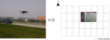
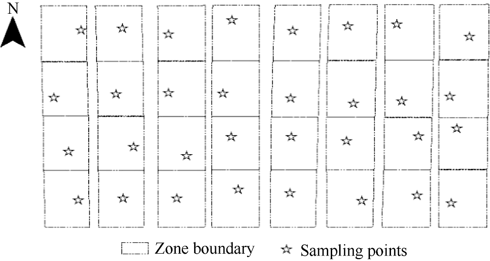
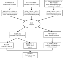
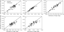
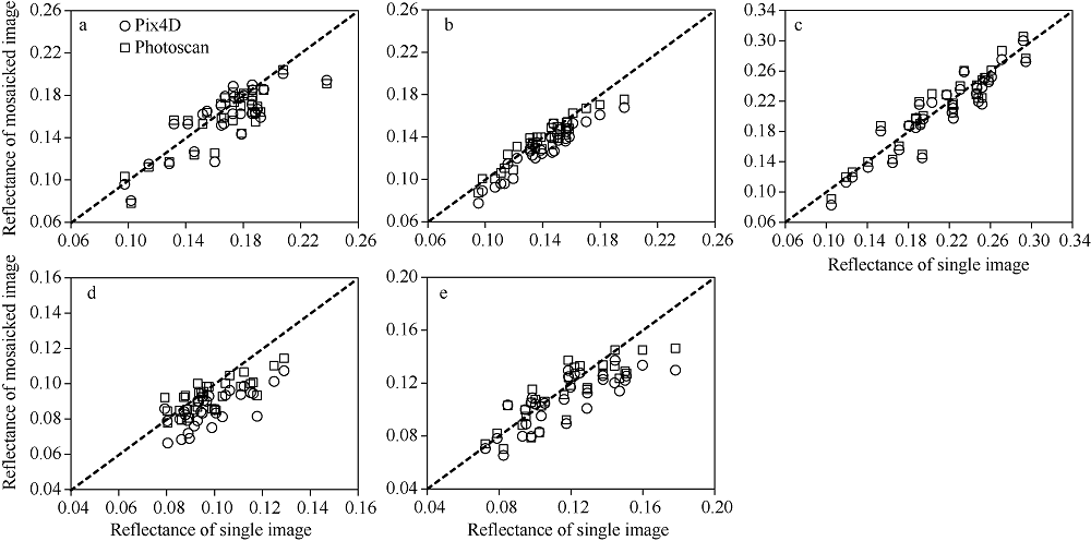
无人机遥感为精准农业管理提供了新的工具。实现无人机影像高精度自动拼接是开展无人机遥感应用的基础。目前, 已有不同无人机影像拼接软件在几何精度方面性能比较的研究, 但关于光谱精度方面还未有相关研究, 而其对定量遥感反演非常重要。本研究比较了目前最受欢迎的两款无人机拼接软件Pix4D和Photoscan在农业应用时, 拼接影像过程对原始影像光谱信息的影响, 以为用户推荐最优软件。为此, 基于冬小麦氮肥梯度试验, 本研究在小麦生长季利用无人机搭载多光谱传感器获取相关影像, 并将其分别基于Pix4D软件, Photoscan软件拼接处理。同时, 基于传感器厂商提供的单张影像处理技术, 将每次传感器拍摄数据处理成未拼接的单张多光谱影像。基于以上数据, 在施肥处理小区随机布设样点, 分别提取3种类型影像上的样点光谱信息, 比较它们光谱反射率及其对比度的差异。结果表明, 尽管Pix4D拼接影像和Photoscan拼接影像各波段光谱反射率都与单张影像的反射率有显著相关性, 但与Pix4D拼接影像相比, Photoscan拼接影像的光谱反射率和变异系数与原始单张影像之间更为接近。Photoscan能保留更多的原始光谱信息。结合已有关于两款软件在几何精度和价格方面的比较研究, 本研究推荐Photoscan为农业应用时的最优性价比软件。
| [1] |
Chen P, Haboudane D, Tremblay N, Wang J, Vigneault P, Li B. New spectral indicator assessing the efficiency of crop nitrogen treatment in corn and wheat. Remote Sens Environ, 2010,114:1987-1997.
doi: 10.1016/j.rse.2010.04.006 |
| [2] |
吴琼, 齐波, 赵团结, 姚鑫锋, 朱艳, 盖钧镒. 高光谱遥感估测大豆冠层生长和籽粒产量的探讨. 作物学报, 2013,39:309-318.
doi: 10.3724/SP.J.1006.2013.00309 |
|
Wu Q, Qi B, Zhao T J, Yao X F, Zhu Y, Gai J Y. A tentative study on utilization of canopy hyperspectral reflectance to estimate canopy growth and seed yield in soybean. Acta Agron Sin, 2013,39:309-318 (in Chinese with English abstract).
doi: 10.3724/SP.J.1006.2013.00309 |
|
| [3] |
John R, Chen J Q, Giannico V, Park H, Xiao J F, Shirkey G, Ouyang Z T, Shao C L, Lafortezza R, Qi J G. Grassland canopy cover and aboveground biomass in Mongolia and Inner Mongolia: Spatiotemporal estimates and controlling factors. Remote Sens Environ, 2018,213:34-48.
doi: 10.1016/j.rse.2018.05.002 |
| [4] | Rumpler M, Daftry S, Tscharf A, Prettenthaler R, Hoppe C, Mayer G, Bischof H. Automated end-to-end workflow for precise and geo-accurate reconstractions using fiducial markers. ISPRS Ann Photogramm Remote Sens Spat Inf Sci, 2014, II-3:135-142. |
| [5] | 陈鹏飞. 无人机在农业的应用现状与展望. 浙江大学学报(农业与生命科学版), 2018,44:399-406. |
| Chen P F. Application status and prospect of UAV in agriculture. J Zhejiang Univ (Agric Life Sci), 2018,44:399-406 (in Chinese with English abstract). | |
| [6] |
李德仁, 李明. 无人机遥感系统的研究进展与应用前景. 武汉大学学报(信息科学版), 2014,39:505-513.
doi: 10.13203/j.whugis20140045 |
|
Li D R, Li M. Research progress and application prospect of UAV remote sensing system. J Wuhan Univ (Inf Sci Edn), 2014,39:505-513 (in Chinese with English abstract).
doi: 10.13203/j.whugis20140045 |
|
| [7] | Aasen H, Burkart A, Bolten A, Bareth G. Generating 3D hyperspectral information with lightweight UAV snapshot cameras for vegetation monitoring: from camera calibration to quality assurance. ISPRS J Photogramm Remote Sens, 2015,108:245-259. |
| [8] | 高林, 杨贵军, 李长春, 冯海宽, 徐波, 王磊, 董锦绘, 付奎. 基于光谱特征与PLRS结合的叶面积指数拟合方法的无人机画幅高光谱遥感应用. 作物学报, 2017,43:549-557. |
| Gao L, Yang G J, Li C C, Feng H K, Xu B, Wang L, Dong J H, Fu K. Application of an improved method in retrieving leaf area index combined spectral index with PLSR in hyperspectral data generated by unmanned aerial vehicle snapshot camera. Acta Agron Sin, 2017,43:549-557 (in Chinese with English abstract). | |
| [9] |
Shafian S, Rajan N, Schnell R, Bagavathiannan M, Valasek J. Unmanned aerial systems-based remote sensing for monitoring sorghum growth and development. PLoS One, 2018,13:e0196605.
pmid: 29715311 |
| [10] |
Zhou G. Near real-time orthorectification and mosaic of small UAV video flow for time-critical event response. IEEE Trans Geosci Remote Sens, 2009,47:739-747.
doi: 10.1109/TGRS.2008.2006505 |
| [11] | 董梅, 苏建东, 杨举田, 刘广玉, 李乃会, 黄泽祥, 田雷. 大区域无人机影像快速无缝拼接方法. 测绘科学, 2014,39(11):129-132. |
| Dong M, Su J D, Yang J T, Liu G Y, Li N H, Huang Z Y, Tian L. A fast seamless image mosaic method for UAV images in large areas. Sci Surv Map, 2014,39(11):129-132 (in Chinese with English abstract). | |
| [12] | 王欢, 蒋显岚. 4种无人机遥感影像快速拼接方法的试验分析. 测绘与空间地理信息, 2015,38(8):117-118. |
| Wang H, Jiang X L. Experimental analysis of 4 kind of remote sensing image mosaic method for UAV. Geomat Spat Inf Technol, 2015,38(8):117-118. | |
| [13] |
Turner D, Lucieer A, Watson C. An automated technique for generating georectified mosaics from ultra-high resolution unmanned aerial vehicle (UAV) imagery, based on structure from motion (SfM) point Clouds. Remote Sens, 2012,4:1392-1410.
doi: 10.3390/rs4051392 |
| [14] |
Gross J W, Heumann B W. A statistical examination of image stitching software packages for use with unmanned aerial systems. Photogramm Eng Remote Sens, 2016,82:419-425.
doi: 10.14358/PERS.82.6.419 |
| [15] | Barazzetti L, Remondino F, Scaioni M. Automation in 3D reconstruction: Results on different kinds of close-range blocks. Int Arch Photogramm Remote Sens Spat Inf Sci, 2010,38:55-61. |
| [16] | Westoby M, Brasington J, Glasser N, Hambrey M, Reynolds J. Structure-from-motion photogrammetry: a low-cost, effective tool for geoscience applications. Geomorphology, 2012,179:300-314. |
| [17] |
Vasuki Y, Holden E J, Kovesi P, Micklethwaite S. Semi-automatic mapping of geological Structures using UAV-based photogrammetric data: An image analysis approach. Comput Geosci (UK), 2014,69:22-32.
doi: 10.1016/j.cageo.2014.04.012 |
| [18] | Sona G, Pinto L, Pagliari D, Passoni D, Gini R. Experimental analysis of different software packages for orientation and digital surface modeling from UAV images. Earth Sci Inf, 2014,7:97-107. |
| [19] |
Turner D, Lucieer A, Wallace L. Direct georeferencing of ultrahigh-resolution UAV imagery. IEEE Trans Geosci Remote Sens, 2014,52:2738-2745.
doi: 10.1109/TGRS.36 |
| [1] | 李祎君, 吕厚荃. 气候变化背景下农业气象灾害对东北地区春玉米产量影响[J]. 作物学报, 2022, 48(6): 1537-1545. |
| [2] | 张建, 谢田晋, 尉晓楠, 王宗铠, 刘崇涛, 周广生, 汪波. 无人机多角度成像方式的饲料油菜生物量估算研究[J]. 作物学报, 2021, 47(9): 1816-1823. |
| [3] | 付虹雨, 崔国贤, 李绪孟, 佘玮, 崔丹丹, 赵亮, 苏小惠, 王继龙, 曹晓兰, 刘婕仪, 刘皖慧, 王昕惠. 基于无人机遥感图像的苎麻产量估测研究[J]. 作物学报, 2020, 46(9): 1448-1455. |
| [4] | 高超,李学文,孙艳伟,周婷,罗纲,陈财. 淮河流域夏玉米生育阶段需水量及农业干旱时空特征[J]. 作物学报, 2019, 45(2): 297-309. |
| [5] | 高林,杨贵军,李长春,冯海宽,徐波,王磊,董锦绘,付奎. 基于光谱特征与PLSR结合的叶面积指数拟合方法的无人机画幅高光谱遥感应用[J]. 作物学报, 2017, 43(04): 549-557. |
| [6] | 陈彦清,曹永生,方沩*,陈丽娜. 综合农业分区尺度下农作物种质资源的空间分布特征[J]. 作物学报, 2017, 43(03): 378-388. |
| [7] | 史磊刚, 范士超, 孔凡磊, 陈阜. 华北平原主要作物生产的碳效率研究初报[J]. 作物学报, 2011, 37(08): 1485-1490. |
| [8] | 金之庆;石春林;葛道阔;高亮之;杨星卫;薛正平;陆贤;丁美花. 基于RCSODS的直播水稻精确施氮模拟模型[J]. 作物学报, 2003, 29(03): 353-359. |
| [9] | 王克晶;余建章;李福山. 我国大豆种皮过氧化物酶活性和根部荧光性基因表型频率分布[J]. 作物学报, 1990, 16(03): 276-283. |
| [10] | 俞履圻. 读《印度农业史》,评普通栽培稻种起源问题[J]. 作物学报, 1989, 15(01): 86-93. |
|
||