欢迎访问作物学报,今天是
作物学报 ›› 2020, Vol. 46 ›› Issue (9): 1448-1455.doi: 10.3724/SP.J.1006.2020.04020
付虹雨1( ), 崔国贤1,2,*(), 李绪孟2,*(), 佘玮1, 崔丹丹1, 赵亮1, 苏小惠1, 王继龙1, 曹晓兰1, 刘婕仪1, 刘皖慧1, 王昕惠1
FU Hong-Yu1(), CUI Guo-Xian1,2,*(), LI Xu-Meng2,*(), SHE Wei1, CUI Dan-Dan1, ZHAO Liang1, SU Xiao-Hui1, WANG Ji-Long1, CAO Xiao-Lan1, LIU Jie-Yi1, LIU Wan-Hui1, WANG Xin-Hui1
摘要:
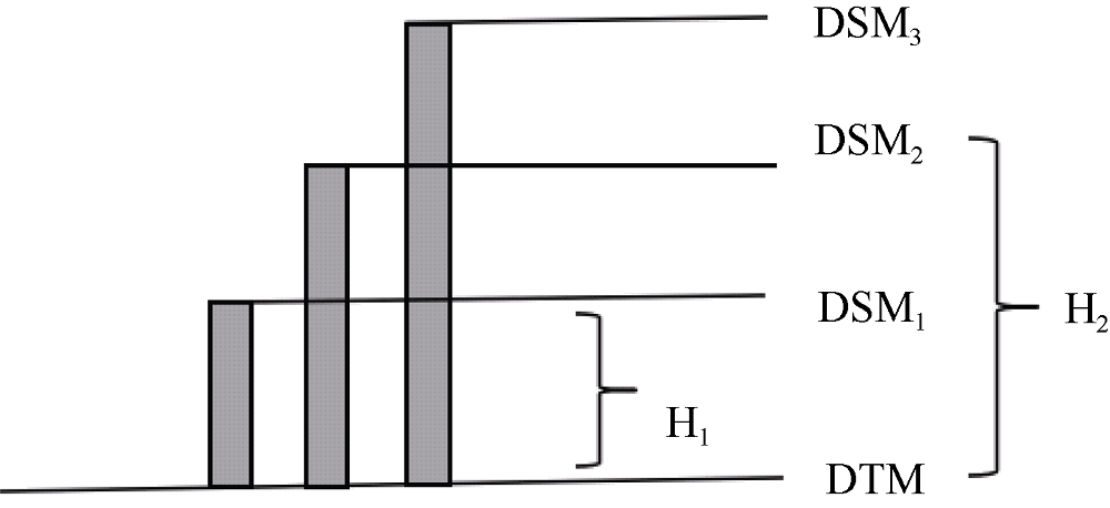
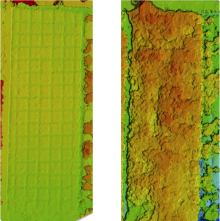
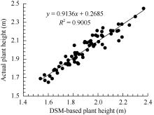
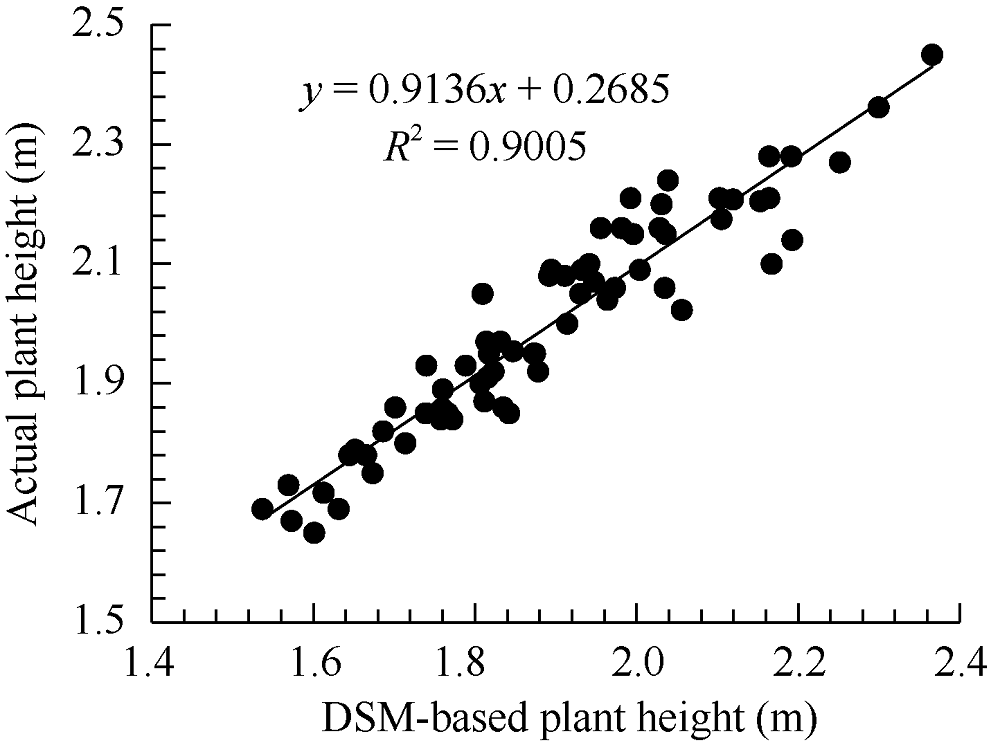
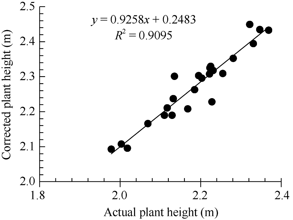
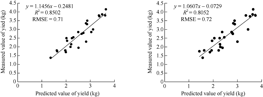
本研究旨在探索一种利用无人机-RGB系统提取的苎麻株高和可见光图像光谱信息估测产量的新方法。试验于2019年在湖南农业大学耘园苎麻基地进行, 利用无人机搭载高清数码相机获取二季苎麻苗期和成熟期的图像。首先利用Pix4D mapper生成苎麻冠层2个生育期的数字表面模型和高清数码正射图像; 然后基于数字表面模型采用“差分法”计算试验小区的平均株高(DSM-based H); 基于正射图像提取试验小区RGB通道均值, 进而计算遥感图像数码变量和植被指数, 分析苎麻种质间的图像光谱表型性状和产量株高比性状的差异性与多样性; 最后采用逐步回归方法建立苎麻产量预测模型, 并对各项产量解释因子进行相关性分析。结果表明: (1)基于无人机-RGB系统遥感株高与实测株高显著相关(r=0.90), 修正遥感株高的均方根误差为0.04 m。(2)苎麻产量与株高信息存在极显著相关性(r=0.91), 而与图像光谱表型相关性不明显。(3)融合遥感图像株高和种质特征差异构建的苎麻产量估测模型精度较高, R2=0.85, RMSE=0.71。因此, 基于无人机遥感图像的苎麻产量估测是可行的, 这对苎麻种质特征评价和产量估测具有重要的意义。
| [1] | Becker-Reshef I, Vermote E, Lindeman M, Justice C. A generalized regression-based model for forecasting winter wheat yields in Kansas and Ukraine using MODIS data. Remote Sens Environ, 2010,114:1312-1323. |
| [2] | Michael S, Antje G, Franziska G, Michael P. Monitoring agronomic parameters of winter wheat crops with low-cost UAV imagery. Remote Sens, 2016,8:706. |
| [3] | Zhang J, Yang C H, Song H B, Zhang G Z. Evaluation of an airborne remote sensing platform consisting of two consumer-grade cameras for crop identification. Remote Sens, 2016,8:257. |
| [4] | 李明, 黄愉淇, 李绪孟, 彭冬星, 谢景鑫. 基于无人机遥感图像的水稻种植信息提取. 农业工程学报, 2018,34(4):108-111. |
| Li M, Huang Y Q, Li X M, Peng D X, Xie J X. Extraction of rice planting information based on remote sensing image from UAV. Trans CSAE, 2018,34(4):108-111 (in Chinese with English abstract). | |
| [5] | Juliane B, Andreas B, Georg B. UAV-based imaging for multi-temporal, very high resolution crop surface models to monitor crop growth variability. Photogr Fernerk Geoinf, 2013,6:551-562. |
| [6] | 杨琦, 叶豪, 黄凯, 查元源, 史良胜. 利用无人机图像构建作物表面模型估测甘蔗LAI. 农业工程学报, 2017,33(8):112-119. |
| Yang Q, Ye H, Huang K, Zha Y Y, Shi L S. Estimation of leaf area index of sugarcane using crop surface model based on UAV image. Trans CSAE, 2017,33(8):112-119 (in Chinese with English abstract). | |
| [7] | Malambo L, Popescu S C, Murray S C. Multitemporal field-based plant height estimation using 3D point clouds generated from small unmanned aerial systems high-resolution imagery. Int J Appl Earth Observ Geoinf, 2018,64:31-42. |
| [8] | Hu P C, Chapman S, Chapman S C, Wang X M, Andries P, Duan T, David J, Guo Y, Zheng B Y. Estimation of plant height using a high throughput phenotyping platform based on unmanned aerial vehicle and self-calibration: example for sorghum breeding. Eur J Agron, 2018,95:24-32. |
| [9] | Juliane B, Andreas B, Simon B, Janis B, Silas E, Georg B. Estimating biomass of barley using crop surface models (CSMs) derived from UAV-based RGB imaging. Remote Sens, 2014,6:10395-10412. |
| [10] | Juliane B, Andreas B, Georg B. Introducing a low-cost mini-UAV for thermal-and multispectral-imaging. Remote Sens Spatial Inf Sci, 2012, XXXIX-B1:345-349. |
| [11] | Gašparović M, Seletković A, Alen B, Ivan B. The evaluation of Photogrammetry-based DSM from low-cost UAV by lidar-based DSM. South-East Eur For, 2017,8:117-125. |
| [12] | 田明璐, 班松涛, 常庆瑞, 罗丹, 王力, 王烁. 基于低空无人机成像光谱仪图像估算棉花叶面积指数. 农业工程学报, 2016,32(21):102-108. |
| Tian M L, Ban S T, Chang Q R, Luo D, Wang L, Wang S. Use of hyperspectral images from UAV-based imaging spectrora diometer to estimate cotton leaf area index. Trans CSAE, 2016,32(21):102-108 (in Chinese with English abstract). | |
| [13] | 陈仲新, 任建强, 唐华俊, 史云, 冷佩, 刘佳, 王利民, 吴文斌, 姚艳敏, 哈斯图亚. 农业遥感研究应用进展与展望. 遥感学报, 2016,20:748-767. |
| Chen Z X, Ren J G, Tang H J, Shi Y, Leng P, Liu J, Wang L M, Wu W B, Yao Y M, Hasituya. Progress and perspectives on agricultural remote sensing research and applications. J Remote Sens, 2016,20:748-767 (in Chinese with English abstract). | |
| [14] | 李井会, 朱丽丽, 宋述尧. 数字图像技术在马铃薯氮素营养诊断中的应用. 安徽农业科学, 2012,40:3303-3305. |
| Li J H, Zhu L L, Song S Y. Application of digital image technology in diagnosis of potato nitrogen nutrition. J Anhui Agric Sci, 2012,40:3303-3305 (in Chinese with English abstract). | |
| [15] | Hunt J E R, Cavigelli M, Daughtry C S T, James E, Charles L. Walthall. Evaluation of digital photography from model aircraft for remote sensing of crop biomass and nitrogen status. Precision Agric, 2005,6:359-378. |
| [16] | 李长春, 牛庆林, 杨贵军, 冯海宽, 刘建刚, 王艳杰. 基于无人机数码图像的大豆育种材料叶面积指数估测. 农业机械学报, 2017,48(8):147-158. |
| Li C C, Niu Q L, Yang G J, Feng H K, Liu J G, Wang Y J. Estimation of leaf area index of soybean breeding materials based on UAV digital images. Trans CSAM, 2017,48(8):147-158 (in Chinese with English abstract). | |
| [17] | Anjin C, Jinha J, Murilo M, Landivar J. Crop height monitoring with digital imagery from unmanned aerial system. Comp Electron Agric, 2017,141:232-237. |
| [18] | 牛庆林, 冯海宽, 杨贵军. 基于无人机数码图像的玉米育种材料株高和LAI监测. 农业工程学报, 2018,34(5):73-81. |
| Niu Q L, Feng H K, Yang G J. Plant height and LAI monitoring of maize breeding materials based on UAV digital image. Trans CSAE, 2018,34(5):73-81 (in Chinese with English abstract). | |
| [19] |
Watanabe K, Guo W, Arai K. High-throughput phenotyping of sorghum plant height using an unmanned aerial vehicle and its application to genomic prediction modeling. Front Plant Sci, 2017,8:421.
doi: 10.3389/fpls.2017.00421 pmid: 28400784 |
| [20] |
Juliane B, Kang Y, Helge A, Andreas B, Simon B, Janis B, Martin L, Georg B. Combining UAV-based plant height from crop surface models, visible, and near infrared vegetation indices for biomass monitoring in barley. Int J Appl Earth Observ Geoinf, 2015,39:79-87.
doi: 10.1016/j.jag.2015.02.012 |
| [21] | Geipel J, Link J, Claupein W. Combined spectral and spatial modeling of corn yield based on aerial images and crop surface models acquired with an unmanned aircraft system. Remote Sens, 2014,6:10335. |
| [22] |
Li W, Niu Z, Chen H Y, Dong L, Wu M Q, Zhao W. Remote estimation of canopy height and aboveground biomass of maize using high-resolution stereo images from a low-cost unmanned aerial vehicle system. Ecol Indicators, 2016,67:637-648.
doi: 10.1016/j.ecolind.2016.03.036 |
| [23] | Louhaichi M, Borman M M, Johnson D E. Spatially located platform and aerial photography for documentation of grazing impacts on wheat. Geocarto Int, 2001,16:65-70. |
| [24] | Woebbecke D, Meyer G, Bargen K V, Mortensen D. Color indices for weed identification under various soil, residue, and lighting conditions. Am Soc Agric Biol Eng, 1995,38:259-269. |
| [25] | Shannon C E, Weaver W. The Mathem Atical Theory of Communication. Urbana: University of Illinoispress, 1994. pp 3-14. |
| [26] |
Jay S, Rabatel G, Hadoux X, Moura D, Gorretta N. In-field crop row phenotyping from 3D modeling performed using structure from motion. Computers Electron Agric, 2015,110:70-77
doi: 10.1016/j.compag.2014.09.021 |
| [27] | 马稚昱, 清水浩, 辜松. 基于机器视觉的菊花生长自动无损监测技术. 农业工程学报, 2010,26(9):213-219. |
| Ma Z Y, Qing S H, Gu S. Non-destructive measurement system for plant growth information based on machine vision. Trans CSAE, 2010,26(9):203-209 (in Chinese with English abstract). | |
| [28] |
Xu W, Daljit S, Sandeep M, Geoffrey M, Jesse P. Field-based high-throughput phenotyping of plant height in sorghum using different sensing technologies. Plant Methods, 2018,14:53.
doi: 10.1186/s13007-018-0324-5 pmid: 29997682 |
| [29] |
Holman F, Riche A B, Michalski A, Castle M, Wooster M, Hawkesford M. High throughput field phenotyping of wheat plant height and growth rate in field plot trials using UAV based remote sensing. Remote Sens, 2016,8:1031.
doi: 10.3390/rs8121031 |
| [30] |
Tonkin T N, Midgley N G. Ground-control networks for image based surface reconstruction: an investigation of optimum survey designs using UAV derived imagery and structure-from-motion photogrammetry. Remote Sens, 2016,8:786.
doi: 10.3390/rs8090786 |
| [31] |
Munoz J D, Finley A O, Gehl R, Kravchenko S. Nonlinear hierarchical models for predicting cover crop biomass using normalized difference vegetation index. Remote Sens Environ, 2010,114:2833-2840.
doi: 10.1016/j.rse.2010.06.011 |
| [32] |
Meyer G E, Neto J C. Verification of color vegetation indices for automated crop imaging applications. Comp Electron Agric, 2008,63:282-293.
doi: 10.1016/j.compag.2008.03.009 |
| [1] | 胡川, 赵凯男, 黄修利, 吴金芝, 任开明, 王贺正, 付国占, 黄明, 李友军. 一次灌溉下耕作方式和氮肥用量对旱地小麦产量和品质的影响[J]. 作物学报, 2026, 52(6): 1830-1846. |
| [2] | 马胜乾, 王志平, 陈浩天, 窦淑贤, 张燕, 邓艾兴, 张卫建, 原向阳, 宋振伟. 秸秆还田下耕作方式与氮肥施用量对东北玉米产量及土壤团聚体的影响[J]. 作物学报, 2026, 52(6): 1802-1816. |
| [3] | 唐宽强, 李公允, 宋美毅, 赵雪, 常春玲. 大豆株高性状全基因组关联分析及预测模型构建[J]. 作物学报, 2026, 52(6): 1743-1756. |
| [4] | 张思思, 赵向辉, 周洋, 姚云凤, 朱荣昱, 董元杰, 胡国庆, 徐通, 刘兆新. 冬闲期翻耕和绿肥还田对连作花生田土壤理化性质和产量的影响[J]. 作物学报, 2026, 52(5): 1472-1486. |
| [5] | 张宁宁, 滕雨菲, 任娜娜, 魏兴卓, 闫书豪, 樊可心, 王永宏, 陈文康, 张兴华, 朱万超, 徐淑兔, 薛吉全. 201份玉米自交系抗旱表型评价及可塑性分析[J]. 作物学报, 2026, 52(5): 1309-1325. |
| [6] | 张鸿蓉, 王菲儿, 李盼, 仇海龙, 朱静, 赵连豪, 南运有, 何蔚, 樊志龙, 胡发龙, 柴强, 殷文. 减量20%灌水与25%有机肥替代化肥提高青贮玉米产量的光合特性[J]. 作物学报, 2026, 52(5): 1487-1500. |
| [7] | 王宇诚, 张露, 刘阿康, 黄见良, 彭少兵, 袁珅. 基于产量差的作物大面积单产提升策略与展望[J]. 作物学报, 2026, 52(5): 1279-1290. |
| [8] | 赵佳雪, 周龙昊, 郭岂源, 尚伦霄, 王涵, 刘志涛, 陈曦, 张晓佩, 宋宪亮, 毛丽丽. 长期秸秆还田与深松通过改善土壤环境与棉花光合特性提高滨海盐碱地棉花产量[J]. 作物学报, 2026, 52(5): 1548-1560. |
| [9] | 郭星宇, 胡丹, 林苏期, 王梦凯, 谭文峰, 黄传琴. 生物炭配施化肥提高玉米‖大豆下玉米产量和土壤生态系统多功能性[J]. 作物学报, 2026, 52(5): 1536-1547. |
| [10] | 张振, 冯连杰, 石玉, 于振文, 张永丽. 节水补灌下不同穗型小麦产量形成差异研究[J]. 作物学报, 2026, 52(5): 1522-1535. |
| [11] | 闫安, 蒋昆炜, 王蓉圆, 田林, 张璐, 王韵, 徐建龙. 水稻剑叶小维管束数基因SVN7的鉴定与克隆[J]. 作物学报, 2026, 52(5): 1364-1372. |
| [12] | 刘昕萌, 任昊, 张继波, 张吉旺, 赵斌, 任佰朝, 刘鹏, 王洪章. 茉莉酸甲酯(MeJA)缓解高温影响玉米雌穗分化的生理机制[J]. 作物学报, 2026, 52(5): 1561-1572. |
| [13] | 王壮壮, 武紫君, 张永新, 张芯源, 袁丽雪, 陈如雪, 刘世举, 段剑钊, 冯伟, 王同朝, 王永华. 豫东南黏壤潮土区水氮优化协同提高冬小麦产量和氮素利用效率[J]. 作物学报, 2026, 52(5): 1501-1521. |
| [14] | 蔡宏玮, 于爱忠, 姜科强, 王鹏飞, 王玉珑, 霍建喆, 庞小能, 尹波, 尚永盼. 干旱灌区有机肥替代部分化肥促进甜玉米产量提升的关键机制[J]. 作物学报, 2026, 52(4): 1166-1180. |
| [15] | 崔雪梅, 柳妍娣, 刘景辉, 米俊珍, 武俊英, 赵宝平. 不同基因型燕麦强弱势粒生理特性与产量关系研究[J]. 作物学报, 2026, 52(4): 1220-1235. |
|
||