欢迎访问作物学报,今天是
作物学报 ›› 2019, Vol. 45 ›› Issue (7): 1099-1110.doi: 10.3724/SP.J.1006.2019.81065
陈梦露1,2,李存军1,*( ),官云兰2,周静平1,王道芸2,罗正乾3
CHEN Meng-Lu1,2,LI Cun-Jun1,*(),GUAN Yun-Lan2,ZHOU Jing-Ping1,WANG Dao-Yun2,LUO Zheng-Qian3
摘要:
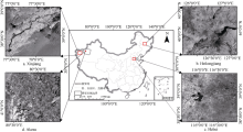
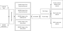
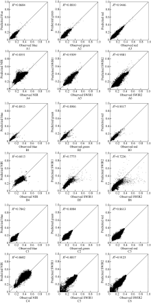
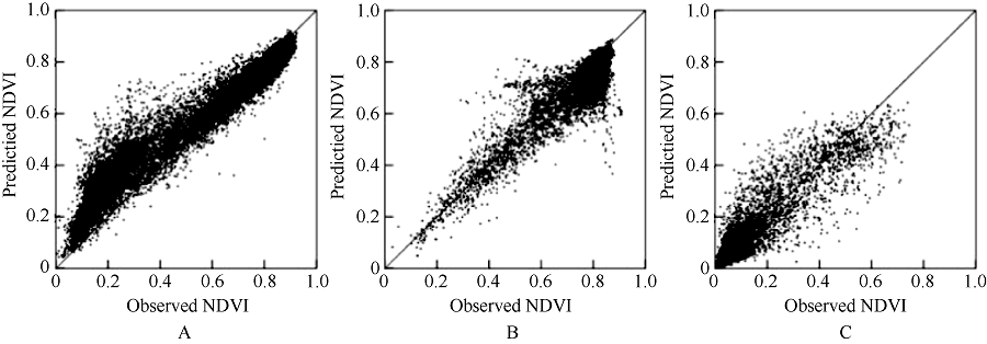
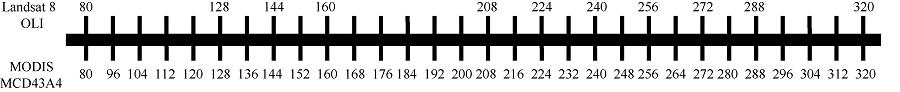
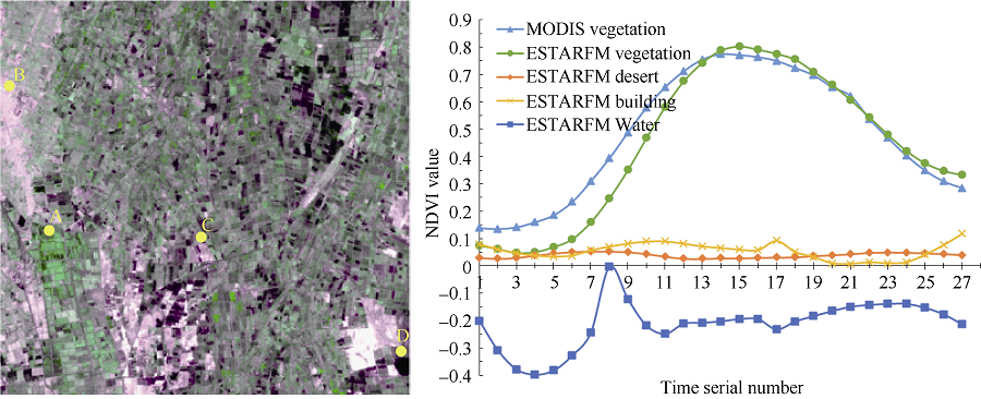
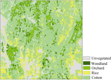
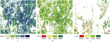
多时相遥感影像特别是关键生育期数据是农业物候、长势及产量监测的重要数据源, 然而可见光影像易受云雨干扰, 在特定区域关键时间窗口缺少高时空分辨率数据的现实情况下, 遥感影像时空数据融合方法变得尤为重要。增强型自适应反射率时空融合模型ESTARFM (Enhanced Spatial and Temporal Adaptive Reflectance Fusion Model)是一种小区域合成高时空分辨率影像的较好方法, 该算法在我国不同农业种植区的适应性及应用工作尚未充分展开。本文以河北、黑龙江、新疆典型农区为研究区域进行大面积应用检验分析, 基于MODIS与Landsat影像, 利用ESTARFM生成具有高时空特征的Landsat模拟影像, 将其与真实Landsat影像进行对比, 并在新疆地区展开ESTARFM算法在NDVI方面的应用。结果表明, ESTARFM对3个不同区域状况的地区都有较好的影像预测能力, 并且在新疆地区可以很好地生成30 m空间分辨率的多时相NDVI, 用于作物分类和长势监测。
| [1] |
Ju J, Roy D P . The availability of cloud-free Landsat ETM+ data over the conterminous United States and globally. Remot Sens Environ, 2008,112:1196-1211.
doi: 10.1016/j.rse.2007.08.011 |
| [2] |
Pohl C, Genderen J L V . Review article multisensor image fusion in remote sensing: Concepts, Methods and Applications. Int J Remot Sens, 1998,19:823-854.
doi: 10.1080/014311698215748 |
| [3] |
Jarihani A A, McVicar T R, Van Niel T G, Emelyanova I V, Callow J N, Johansen K . Blending Landsat and MODIS data to generate multispectral indices: a comparison of “Index-then- Blend” and “Blend-then-Index” approaches. Remot Sens, 2014,6:9213-9238.
doi: 10.3390/rs6109213 |
| [4] | 石月婵 . 基于多源遥感数据的高时空地表温度生成方法研究. 山东科技大学硕士学位论文, 山东青岛, 2013. |
| Shi Y C . Research on the Generation of High Temporal and Spatial land Surface Temperature Based on Multi-source Remote Sensing Data. MS Thesis of Shandong University of Science and Technology, Qingdao, Shandong, China, 2013 (in Chinese with English abstract). | |
| [5] |
Gao F, Masek J, Schwaller M, Hall F . On the blending of the Landsat and MODIS surface reflectance: predicting daily Landsat surface reflectance. IEEE Transact Geosci Remot Sens, 2006,44:2207-2218.
doi: 10.1109/TGRS.2006.872081 |
| [6] |
Knauer K, Gessner U, Fensholt R, Kuenzer C . An ESTARFM fusion framework for the generation of large-scaletime series in cloud-prone and heterogeneous landscapes. Remot Sens, 2016,8:425.
doi: 10.3390/rs8050425 |
| [7] |
Hilker T, Wulder M A, Coops N C, Linke J, Mcdermid G, Masek J G, Gao F, White J C . A new data fusion model for high spatial-and temporal-resolution mapping of forest disturbance based on Landsat and MODIS. Remot Sens Environ, 2009,113:1613-1627.
doi: 10.1016/j.rse.2009.03.007 |
| [8] |
Zhu X L, Chen J, Gao F, Chen X H, Masek J G . An enhanced spatial and temporal adaptive reflectance fusion model for complex heterogeneous regions. Remot Sens Environ, 2010,114:2610-2623.
doi: 10.1016/j.rse.2010.05.032 |
| [9] |
Emelyanova I V, Mcvicar T R, Van Niel T G, Li L T, van Dijk A I J M . Assessing the accuracy of blending Landsat-MODIS surface reflectances in two landscapes with contrasting spatial and temporal dynamics: A framework for algorithm selection. Remot Sens Environ, 2013,133:193-209.
doi: 10.1016/j.rse.2013.02.007 |
| [10] |
Chen B, Huang B, Xu B . Comparison of spatiotemporal fusion models: a review. Remot Sens, 2015,7:1798-1835.
doi: 10.3390/rs70201798 |
| [11] |
Liao C H, Wang J F, Pritchard I, Liu J G, Shang J L . A spatio-temporal data fusion model for generating NDVI time series in heterogeneous regions. Remot Sens, 2017,9:1125.
doi: 10.3390/rs9111125 |
| [12] |
Knauer K, Gessner U, Fensholt R, Forkuor G, Kuenzer C . Monitoring agricultural expansion in Burkina Faso over 14 years with 30 m resolution time series: the role of population growth and implications for the environment. Remot Sens, 2017,9:132.
doi: 10.3390/rs9020132 |
| [13] |
Wu M Q, Niu Z, Wang C Y, Wu C Y, Wang L . Use of MODIS and Landsat time series data to generate high-resolution temporal synthetic Landsat data using a spatial and temporal reflectance fusion model. J Appl Remot Sens, 2012,6:063507.
doi: 10.1117/1.JRS.6.063507 |
| [14] | 石月婵, 杨贵军, 李鑫川, 宋健, 王纪华, 王锦地 . 融合多源遥感数据生成高时空分辨率数据的方法对比. 红外与毫米波学报, 2015,34:92-99. |
| Shi Y C, Yang G J, Li X C, Song J, Wang J H, Wang J D . Comparison of methods for generating high temporal and spatial resolution data by using multi-source remote sensing data. J Infrared Millimeter Wave, 2015,34:92-99 (in Chinese with English abstract). | |
| [15] |
Wu M Q, Wu C Y, Huang W J, Niu Z, Wang C Y, Li W, Hao P Y . An improved high spatial and temporal data fusion approach for combining Landsat and MODIS data to generate daily synthetic Landsat imagery. Inform Fusion, 2016,31:14-25.
doi: 10.1016/j.inffus.2015.12.005 |
| [16] | 周巍, 朱荣, 张锦水 . 遥感辅助的农作物种植面积小域估计方法研究. 统计研究, 2015,32(7):81-86. |
| Zhou W, Zhu R, Zhang J S . A study on small area estimation for crop acreage in remote sensing assisted crop survey. Stat Res, 2015,32(7):81-86 (in Chinese with English abstract). | |
| [17] | 侯博展, 陈蜀江, 侯建楠, 黄铁成, 贾翔 . 基于多源多时相数据集的喀什市近70a城区空间扩展遥感研究. 冰川冻土, 2016,38:836-844. |
| Hou B Z, Chen S J, Hou J N, Huang T C, Jia X . Remote sensing study of urban spatial expansion in Kashgar City based on multisource and multi-temporal datasets in the last 70 years. J Glaciology Geocryo, 2016,38:836-844 (in Chinese with English abstract). | |
| [18] | 李国砚, 张仲元, 郑艳芬, 刘晓玫 . MODIS影像的大气校正及在太湖蓝藻监测中的应用. 湖泊科学, 2008,20:160-166. |
| Li G Y, Zhang Z Y, Zheng Y F, Liu X M . Atmospheric correction of MODIS images and its application in cyanobacteria bloom monitoring in Lake Taihu. J Lake Sci, 2008,20:160-166 (in Chinese with English abstract). | |
| [19] |
Bai L L, Cai J B, Liu Y, Chen H, Zhang B Z, Huang L X . Responses of field evapotranspiration to the changes of cropping pattern and groundwater depth in large irrigation district of Yellow River basin. Agric Water Manage, 2017,188:1-11.
doi: 10.1016/j.agwat.2017.03.028 |
| [20] |
Huang C, Chen Y, Zhang S Q, Li L Y, Shi K F, Liu R . Surface water mapping from Suomi NPP-VIIRS imagery at 30 m resolution via blending with Landsat data. Remot Sens, 2016,8:631.
doi: 10.3390/rs8080631 |
| [21] | 郭文静, 李爱农, 赵志强, 王继燕 . 基于AVHRR和TM的时间序列较高分辨率NDVI数据集重构方法. 遥感技术与应用, 2015,30:267-276. |
| Guo W J, Li A N, Zhao Z Q, Wang J Y . Constructing the time-series NDVI dataset with a high spatial and temporal resolution through fusing AVHRR with TM data. Remot Sens Tech Appl, 2015,30:267-276. | |
| [22] | 郝贵斌, 吴波, 张立福, 付东杰, 李瑶 . ESTARFM模型在西藏色林错湖面积时空变化中的应用分析(1976-2014年). 地球信息科学学报, 2016,18:833-846. |
| Hao G B, Wu B, Zhang L F, Fu D J, Li Y . Temporal and spatial variation analysis of the area of Siling Co lake in Tibet based on ESTARFM (1976-2014). J Geo-inform Sci, 2016,18:833-846. (in Chinese with English abstract). | |
| [23] | 杨贵军, 孙晨红, 历华 . 黑河流域ASTER与MODIS融合生成高分辨率地表温度的验证. 农业工程学报, 2015,31(6):193-200. |
| Yang G J, Sun C H, Li H . Verification of high-resolution surface temperature by fusion of ASTER and MODIS in Heihe River Basin. Trans CSAE, 2015,31(6):193-200 (in Chinese with English abstract). | |
| [24] | 吴炳方, 张峰, 刘成林, 张磊, 罗治敏 . 农作物长势综合遥感监测方法. 遥感学报, 2004,8:498-514. |
| Wu B F, Zhang F, Liu C L, Zhang L, Luo Z M . An integrated method for crop condition monitoring. J Remot Sens, 2004,8:498-514 (in Chinese with English abstract). | |
| [25] |
Liu M X, Liu X N, Wu L, Zou X Y, Jiang T, Zhao B Y . A modified spatiotemporal fusion algorithm using phenological information for predicting reflectance of paddy rice in southern china. Remot Sens, 2018,10:772.
doi: 10.3390/rs10050772 |
| [26] |
Zhang W, Li A, Jin H, Bian J H, Zhang Z J, Lei G B, Qin Z H, Huang C Q . An enhanced spatial and temporal data fusion model for fusing Landsat and MODIS surface reflectance to generate high temporal Landsat-like data. Remot Sens, 2013,5:5346-5368.
doi: 10.3390/rs5105346 |
| [27] |
Gärtner P, Förster M, Kleinschmit B . The benefit of synthetically generated RapidEye and Landsat 8 data fusion time series for riparian forest disturbance monitoring. Remot Sens Environ, 2016,177:237-247.
doi: 10.1016/j.rse.2016.01.028 |
| [28] |
Yang G J, Weng Q H, Pu R L, Gao F, Sun C H, Li H, Zhao C J . Evaluation of ASTER-like daily land surface temperature by fusing ASTER and MODIS data during the HiWATER-MUSOEXE. Remot Sens, 2016,8:75.
doi: 10.3390/rs8010075 |
| [29] |
Fu D J, Chen B Z, Wang J, Zhu X L, Hilker T . An improved image fusion approach based on enhanced spatial and temporal the adaptive reflectance fusion model. Remot Sens, 2013,5:6346-6360.
doi: 10.3390/rs5126346 |
| [1] | 王磊,白由路,卢艳丽,王贺,杨俐苹. 基于GreenSeeker的冬小麦NDVI分析与产量估算[J]. 作物学报, 2012, 38(04): 747-753. |
|
||