欢迎访问作物学报,今天是
作物学报 ›› 2018, Vol. 44 ›› Issue (05): 762-773.doi: 10.3724/SP.J.1006.2018.00762
王利民*( ), 刘佳, 杨福刚, 杨玲波, 姚保民, 王小龙
Li-Min WANG*(), Jia LIU, Fu-Gang YANG, Ling-Bo YANG, Bao-Min YAO, Xiao-Long WANG
摘要:
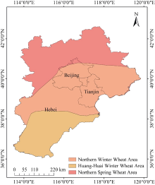
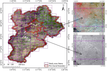
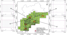
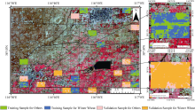
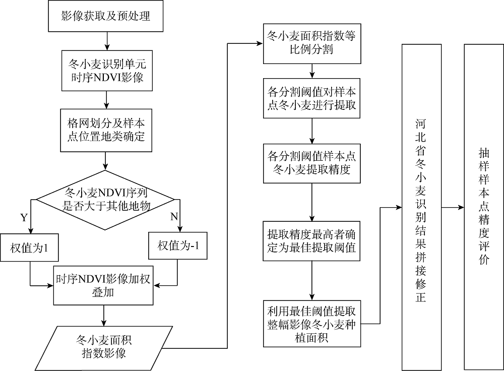
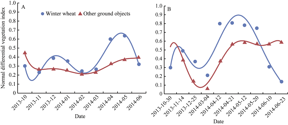
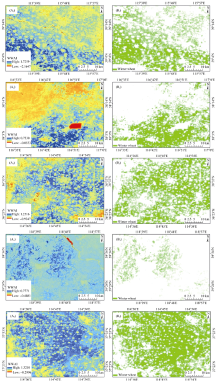
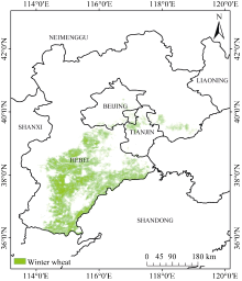
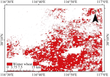
省级尺度冬小麦面积的精准获取技术是农作物面积遥感监测研究的主要内容之一。为了获取省级尺度的冬小麦种植面积, 该文以北京市(京)、天津市(津)和河北省(冀) 3个省域范围为例, 以国家标准地形图分幅为分类的图幅单元, 利用国产GF-1/WFV数据, 构建冬小麦面积指数, 实现了省级尺度冬小麦面积的识别。本文以冬小麦全部9个月生育期的984景影像作为数据源, 依次经过数据预处理、标准图幅单元的NDVI合成、样本点选择、冬小麦面积指数构建、冬小麦作物类型确认、省域范围制图及精度验证等步骤完成研究区域内冬小麦面积的提取。采用区域网平差和6S大气校正算法对数据源预处理, 以中国1︰10万标准地形图分幅为分类图幅单元构建冬小麦面积指数, 将冬小麦面积指数按照1%的比例等分, 并将面积指数从0到100%分割为101个提取节点, 将提取节点的NDVI值依次与类型确认样本比较, 精度最高的则确认为冬小麦面积提取阈值, 同时将该阈值应用于图幅单元内冬小麦面积指数影像, 获取冬小麦种植分布。最后冬小麦面积识别的精度表明, 以标准地图分幅作为计算单元, 在GF-1影像基础上, 利用冬小麦面积指数能够显著提高冬小麦与其他地物类型的波谱差异, 且冬小麦的总体识别精度达到89.6%, 用户精度达到89.8%, 制图精度96.5%, Kappa系数0.72。在典型区域, 本文算法与监督分类算法精度结果较为一致, 除制图精度相差4.77%外, 总体精度与用户精度差都在1.00%以内, 说明本文算法具有精度高、运行效率高、分类单元识别结果一致性强的特点, 能够满足省级尺度农情遥感业务监测的需要。
| [1] |
吴炳方. 中国农情遥感速报系统. 遥感学报, 2004, 8: 481-497
doi: 10.11834/jrs.20040601 |
|
Wu B F.China crop watch system with remote sensing.J Remote Sens, 2004, 8: 481-497 (in Chinese with English abstract)
doi: 10.11834/jrs.20040601 |
|
| [2] | 中华人民共和国统计局. 中国统计年鉴2017 (12-8 农作物播种面积). 北京: 中国统计出版社, 2017 |
| National Bureau of Statistics of the People’s Republic of China. China Statistical Yearbook 2017 (12-8 Sown areas of farm crops). Beijing: China Statistics Press, 2017 (in Chinese with English abstract) | |
| [3] | 杨邦杰, 裴志远. 国家级农情遥感监测系统的研究开发与运行. 农业工程学报, 2003, 19(增刊): 11-14 |
| Yang B J, Pei Z Y.National agricultural condition monitoring system based on satellite remote sensing: development, application and improvement.Trans CSAE, 2003, 19(suppl): 11-14 (in Chinese with English abstract) | |
| [4] |
Tarko A, De Bruin S, Fasbender D, Bregt A.Users’ assessment of orthoimage photometric quality for visual interpretation of agricultural fields. Remote Sens, 2015, 7: 4919-4936
doi: 10.3390/rs70404919 |
| [5] |
Khatami R, mountrakis G, Stehman S V. A meta-analysis of remote sensing research on supervised pixel-based land-cover image classification processes: general guidelines for practitioners and future research.Remote Sens Environ, 2016, 177: 89-100
doi: 10.1016/j.rse.2016.02.028 |
| [6] | Löw F, Duveiller G.Determining suitable image resolutions for accurate supervised crop classification using remote sensing data. In: Proceedings of the SPIE, Vol. 8893: Earth Resources and Environmental Remote Sensing/GIS Applications IV, Dresden, Germany, 2013. pp 909-927 |
| [7] |
Lewiński S A.Object-oriented classification of Landsat ETM+ satellite image. J Water & Land Develop, 2007, 10: 91-106
doi: 10.2478/v10025-007-0008-4 |
| [8] |
Kumar P, Gupta D K, Mishra V N, Prasad R.Comparison of support vector machine, artificial neural network, and spectral angle mapper algorithms for crop classification using LISS IV data.Int J Remote Sens, 2015, 36: 1604-1617
doi: 10.1080/2150704X.2015.1019015 |
| [9] |
Li J, Zhao G X, Yang P G.Knowledge-based land use/cover classification of remote sensing image in Kenli, Shandong Province, China.Chin Sci Bull, 2006, 51: 218-224
doi: 10.1007/s11434-006-8210-3 |
| [10] | 李霞, 王飞, 徐德斌, 刘清旺. 基于混合像元分解提取大豆种植面积的应用探讨. 农业工程学报, 2008, 24(1): 213-217 |
| Li X, Wang F, Xu D B, Liu Q W.Application research on the method for extracting soybean covered areas based on the pixel unmixing.Trans CSAE, 2008, 24(1): 213-217 (in Chinese with English abstract) | |
| [11] | 张建国, 李宪文, 吴延磊. 面向对象的冬小麦种植面积遥感估算研究. 农业工程学报, 2008, 24(5): 156-160 |
| Zhang J G, Li X W, Wu Y L.Object oriented estimation of winter wheat planting area using remote sensing data.Trans CSAE, 2008, 24(5): 156-160 (in Chinese with English abstract) | |
| [12] |
Lennington R K, Sorensen C T, Heydorn R P.A mixture model approach for estimating crop areas from Landsat data.Remote Sens Environ, 1984, 14: 197-206
doi: 10.1016/0034-4257(84)90015-4 |
| [13] | Chellasamy M, Ferré T P A, Greeve M H. Automatic training sample selection for a multi-evidence based crop classification approach. In International Archives of the Photogrammetry, Remote Sensing and Spatial Information Sciences - ISPRS Archives, 7th edn., Vol. 40, 2014. pp 63-69 |
| [14] |
王利民, 刘佳, 高建孟, 杨玲波, 杨福刚, 王小龙. 冬小麦面积遥感识别精度与空间分辨率关系. 农业工程学报, 2016, 32(23): 152-160
doi: 10.11975/j.issn.1002-6819.2016.23.021 |
|
Wang L M, Liu J, Gao J M, Yang L B, Yang F G, Wang X L.Relationship between accuracy of winter wheat area remote sensing identification and spatial resolution. Trans CSAE, 2016, 32(23): 152-160 (in Chinese with English abstract)
doi: 10.11975/j.issn.1002-6819.2016.23.021 |
|
| [15] | 李颖, 陈秀万, 段红伟, 沈阳. 多源多时相遥感数据在冬小麦识别中的应用研究. 地理与地理信息科学, 2010, 26(4): 47-49 |
| Li Y, Chen X W, Duan H W, Shen Y.Application of multi-source and multi-temporal remote sensing data in winter wheat identification.Geog Geo-Inf Sci, 2010, 26(4): 47-49 (in Chinese with English abstract) | |
| [16] |
Conese C, Maselli F.Use of multi-temporal information to improve classification performance of TM scenes in complex terrain.ISPRS J Photogram Remote Sens, 1991, 46: 187-197
doi: 10.1016/0924-2716(91)90052-W |
| [17] |
张喜旺, 秦耀辰, 秦奋. 综合季相节律和特征光谱的冬小麦种植面积遥感估算. 农业工程学报, 2013, 29(8): 154-163
doi: 10.3969/j.issn.1002-6819.2013.08.018 |
|
Zhang X W, Qin Y C, Qin F.Remote sensing estimation of planting area for winter wheat by integrating seasonal rhythms and spectral characteristics.Trans CSAE, 2013, 29(8): 154-163 (in Chinese with English abstract)
doi: 10.3969/j.issn.1002-6819.2013.08.018 |
|
| [18] |
Wardlow B D, Egbert S L.Large-area crop mapping using time- series MODIS 250m NDVI data: an assessment for the U.S. Central Great Plains.Remote Sens Environ, 2008, 112: 1096-1116
doi: 10.1016/j.rse.2007.07.019 |
| [19] |
Zheng B, Myint S W, Thenkabail P S, Aggarwal R M.A support vector machine to identify irrigated crop types using time-series Landsat NDVI data.Int J Appl Earth Observ & Geoinf, 2015, 34: 103-112
doi: 10.1016/j.jag.2014.07.002 |
| [20] |
刘佳, 王利民, 杨福刚, 杨玲波, 王小龙. 基于HJ时间序列数据的农作物种植面积估算. 农业工程学报, 2015, 31(3): 199-206
doi: 10.3969/j.issn.1002-6819.2015.03.026 |
|
Liu J, Wang L M, Yang F G, Yang L B, Wang X L.Remote sensing estimation of crop planting area based on HJ time-series images.Trans CSAE, 2015, 31(3): 199-206 (in Chinese with English abstract)
doi: 10.3969/j.issn.1002-6819.2015.03.026 |
|
| [21] |
Suzuki K, Takeuchi T.Classification of upland crops using multi-temporal RapidEye data.J Jpn Agric Syst Soc, 2015, 31: 1-10
doi: 10.14962/jass.31.1_1 |
| [22] |
Carfagna E, Gallego F J.Using remote sensing for agricultural statistics.Int Statistical Rev, 2005, 73: 389-404
doi: 10.1111/j.1751-5823.2005.tb00155.x |
| [23] | 焦险峰, 杨邦杰, 裴志远. 基于分层抽样的中国水稻种植面积遥感调查方法研究. 农业工程学报, 2006, 22(5): 105-110 |
| Jiao X F, Yang B J, Pei Z Y.Paddy rice area estimation using a stratified sampling method with remote sensing in China.Trans CSAE, 2006, 22(5): 105-110 (in Chinese with English abstract) | |
| [24] |
王增林, 朱大明. 基于遥感影像的最大似然分类算法的探讨. 河南科学, 2010, 28: 1458-1461
doi: 10.3969/j.issn.1004-3918.2010.11.024 |
|
Wang Z L, Zhu D M.A study of maximum likelihood classification algorithm based on remote sensing image.Henan Sci, 2010, 28: 1458-1461 (in Chinese with English abstract)
doi: 10.3969/j.issn.1004-3918.2010.11.024 |
|
| [25] |
Mosleh M K, Hassan Q K, Chowdhury E H.Application of remote sensors in mapping rice area and forecasting its production: a review.Sensors, 2015, 15: 769-791
doi: 10.3390/s150100769 pmid: 4327048 |
| [26] | 王利民, 刘佳, 杨玲波, 杨福刚, 滕飞, 王小龙. 基于NDVI 加权指数的冬小麦种植面积遥感监测. 农业工程学报, 2016, 32(17): 127-135 |
| Wang L M, Liu J, Yang L B, Yang F G, Teng F, Wang X L.Remote sensing monitoring winter wheat area based on weighted NDVI index.Trans CSAE, 2016, 32(17): 127-135 (in Chinese with English abstract) | |
| [27] |
Bargiel D.A new method for crop classification combining time series of radar images and crop phenology information.Remote Sens Environ, 2017, 198: 369-383
doi: 10.1016/j.rse.2017.06.022 |
| [28] |
Massey R, Sankey T T, Congalton R G, Yadav K, Thenkabail P S, Ozdogan M, Meador A J S. MODIS phenology-derived, multi-year distribution of conterminous U.S. crop types.Remote Sens Environ, 2017, 198: 490-503
doi: 10.1016/j.rse.2017.06.033 |
| [1] | 王壮壮, 武紫君, 张永新, 张芯源, 袁丽雪, 陈如雪, 刘世举, 段剑钊, 冯伟, 王同朝, 王永华. 豫东南黏壤潮土区水氮优化协同提高冬小麦产量和氮素利用效率[J]. 作物学报, 2026, 52(5): 1501-1521. |
| [2] | 乔宇馨, 李程越, 康晓玉, 张鑫琪, 贾绍辉, 刘倩, 曹亚丽, 史鑫蕊, 郝兴宇, 李萍. 基于APSIM模型的长期免耕秸秆覆盖对旱地小麦增产效应研究[J]. 作物学报, 2026, 52(4): 1181-1192. |
| [3] | 陈如雪, 孙丽芳, 张芯源, 牟海萌, 张永新, 袁丽雪, 彭仕乐, 王壮壮, 王永华. 秸秆还田与微生物菌剂配施对冬小麦旗叶碳氮代谢及产量形成的影响[J]. 作物学报, 2025, 51(7): 1901-1913. |
| [4] | 吴柳格, 陈坚, 张鑫, 邓艾兴, 宋振伟, 郑成岩, 张卫建. 近二十年国审冬小麦品种的产量与品质性状变化趋势研究[J]. 作物学报, 2025, 51(7): 1814-1826. |
| [5] | 赵刚, 张建军, 党翼, 樊廷录, 王磊, 周刚, 王淑英, 李兴茂, 倪胜利, 米文博, 周旭姣, 程万莉, 李尚中. 黄土旱塬区秸秆覆盖量对不同降雨年型土壤水温效应和冬小麦产量的影响[J]. 作物学报, 2025, 51(6): 1643-1653. |
| [6] | 王东, 王森, 尚丽, 冯浩伟, 张永巧, 崔佳鸣, 李爽, 章佳聪, 车欢. 补灌对黄土高原半湿润区冬小麦产量和水分利用效率的影响[J]. 作物学报, 2025, 51(5): 1312-1325. |
| [7] | 王娇, 白海霞, 韩语燕, 梁惠, 冯雅楠, 张东升, 李萍, 宗毓铮, 史鑫蕊, 郝兴宇. CO2浓度升高、升温及其交互作用对良星99冬小麦叶片碳氮代谢的影响[J]. 作物学报, 2025, 51(4): 1061-1076. |
| [8] | 张妍妍, 李迎, 刘栩辰, 黄超, 吕佳宁, 周海佳, 马守田, 秦安振, 高子乐, 吴光辉, 陈丹, 姬夏楠, 刘战东. 深松耕作条件下滴灌对冬小麦花后干物质积累及灌浆特性的影响[J]. 作物学报, 2025, 51(11): 3065-3079. |
| [9] | 张军, 胡川, 周起晖, 任开明, 董誓言, 刘傲寒, 吴金芝, 黄明, 李友军. 减氮及有机肥替代对旱地冬小麦干物质积累、转运、分配和产量的影响[J]. 作物学报, 2025, 51(1): 207-220. |
| [10] | 彭杰, 谢晓麒, 张钊, 姚晓芬, 邱深, 陈丹丹, 顾晓娜, 王玉洁, 王晨晨, 杨国正. 夏直播棉花产量与冠层微环境的关系[J]. 作物学报, 2024, 50(9): 2371-2382. |
| [11] | 马艳明, 娄鸿耀, 王威, 孙娜, 颜国荣, 张胜军, 刘杰, 倪中福, 徐麟. 新疆冬小麦籽粒品质性状遗传差异与关联分析[J]. 作物学报, 2024, 50(6): 1394-1405. |
| [12] | 黄宏胜, 张馨月, 居辉, 韩雪. 大气CO2浓度升高背景下冬小麦冠层光谱特征和地上生物量估算[J]. 作物学报, 2024, 50(4): 991-1003. |
| [13] | 赵荣荣, 丛楠, 赵闯. 基于Landsat 8影像提取豫中地区冬小麦和夏玉米分布信息的最佳时相选择[J]. 作物学报, 2024, 50(3): 721-733. |
| [14] | 谢炜, 贺鹏, 马宏亮, 雷芳, 黄秀兰, 樊高琼, 杨洪坤. 秋闲期秸秆覆盖与施磷对冬小麦氮素吸收利用的影响[J]. 作物学报, 2024, 50(2): 440-450. |
| [15] | 杨晓慧, 王碧胜, 孙筱璐, 侯靳锦, 徐梦杰, 王志军, 房全孝. 冬小麦对水分胁迫响应的模型模拟与节水滴灌制度优化[J]. 作物学报, 2023, 49(8): 2196-2209. |
|
||