欢迎访问作物学报,今天是
作物学报 ›› 2022, Vol. 48 ›› Issue (9): 2409-2420.doi: 10.3724/SP.J.1006.2022.12066
• 研究简报 • 上一篇
桑国庆1,2( ), 唐志光1,2,*(), 毛克彪3, 邓刚1,2, 王靖文1,2, 李佳1,2
SANG Guo-Qing1,2(), TANG Zhi-Guang1,2,*(), MAO Ke-Biao3, DENG Gang1,2, WANG Jing-Wen1,2, LI Jia1,2
摘要:
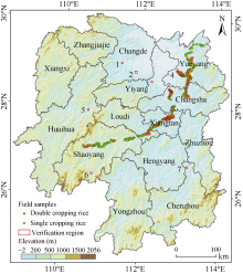
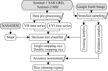
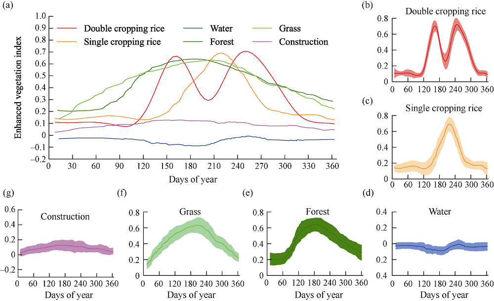
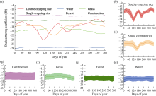
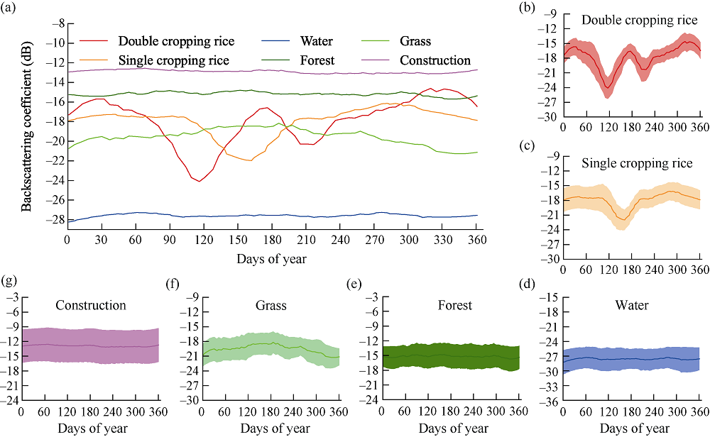
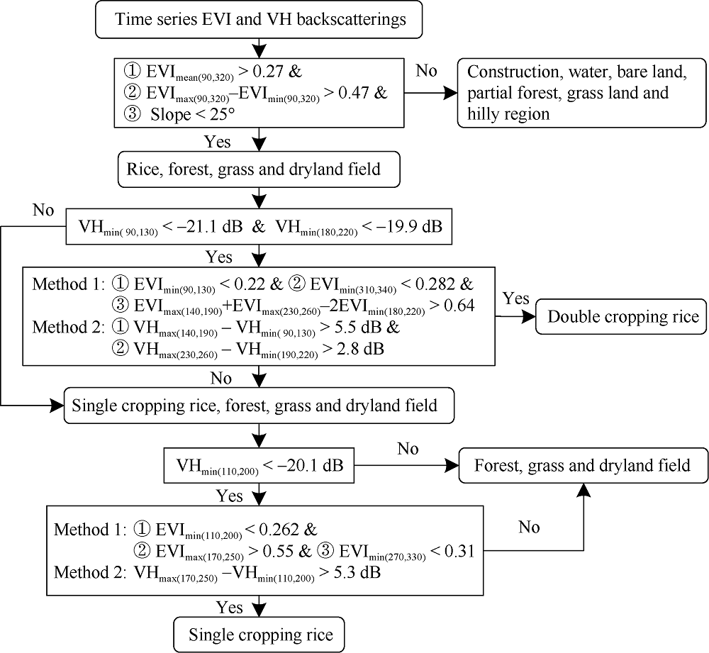
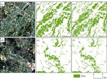
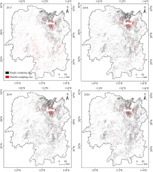
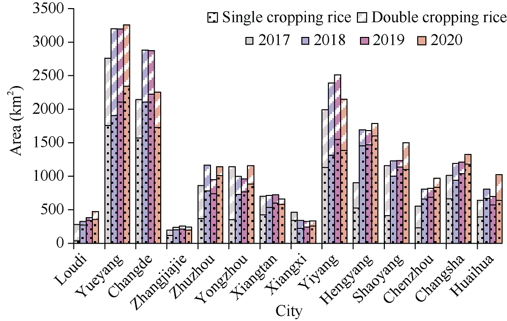
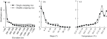
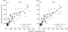
准确获取大范围的水稻种植空间分布信息对调整农业生产结构和保障粮食安全至关重要。本文以湖南省为研究区, 基于谷歌地球引擎(Google Earth Engine, GEE)云平台, 协同Sentinel-1 SAR和Sentinel-2 MSI数据, 根据水稻物候期极化(vertical transmit/horizontal receive, VH)后向散射系数、增强型植被指数(enhanced vegetation index, EVI)的变化特征构建水稻提取决策树模型, 开展高分辨率水稻种植范围遥感提取, 并进行精度验证。结果表明: 本模型能够准确实现多云多雨地区的水稻种植范围遥感制图; 基于混淆矩阵计算水稻总体分类精度为93.97%, Kappa系数为0.908, 单、双季稻F1-score均超过91%, 可为亚热带多云雨且稻田破碎分布区的水稻种植范围遥感提取提供参考。湖南省水稻分布受地形和气温的影响明显, 主要分布在海拔200 m以下, 坡度小于6°, 年均气温大于17℃的区域; 双季稻集中分布在岳阳、常德和益阳市, 而单季稻种植分布相对零散。
| [1] | Zhao C, Piao S, Wang X, Huang Y, Ciais P, Elliott J, Huang M, Janssens I A, Li T, Lian X. Plausible rice yield losses under future climate warming. Nat Plants, 2016, 3: 16202. |
| [2] |
Bouvet A, Le Toan T. Use of ENVISAT/ASAR wide-swath data for timely rice fields mapping in the Mekong River Delta. Remote Sens Environ, 2011, 115: 1090-1101.
doi: 10.1016/j.rse.2010.12.014 |
| [3] |
Iizumi T, Furuya J, Shen Z, Kim W, Okada M, Fujimori S, Hasegawa T, Nishimori M. Responses of crop yield growth to global temperature and socioeconomic changes. Sci Rep, 2017, 7: 7800.
doi: 10.1038/s41598-017-08214-4 |
| [4] |
Dong J, Xiao X, Zhang G, Menarguez M, Choi C, Qin Y, Luo P, Zhang Y, Moore B. Northward expansion of paddy rice in northeastern Asia during 2000-2014. Geophys Res Lett, 2016, 43: 3754-3761.
pmid: 27667876 |
| [5] |
Gao J, Liu Y. Climate warming and land use change in Heilongjiang province, northeast China. Appl Geogr, 2011, 31: 476-482.
doi: 10.1016/j.apgeog.2010.11.005 |
| [6] | Rosada I. Rice-field conversion and its impact on food availability. Agric Sci Proc, 2016, 9: 40-46. |
| [7] | Bouman B, Humphreys E, Tuong T, Barker R. Rice and water. Adv Agron, 2007, 92: 187-237. |
| [8] | 张鹏, 胡守庚. 地块尺度的复杂种植区作物遥感精细分类. 农业工程学报, 2019, 35(20): 125-134. |
| Zhang P, Hu S G. Fine crop classification by remote sensing in complex planting areas based on field parcel. Trans CSAE, 2019, 35(20): 125-134. (in Chinese with English abstract) | |
| [9] | 解毅, 张永清, 荀兰, 柴旭荣. 基于多源遥感数据融合和LSTM算法的作物分类研究. 农业工程学报, 2019, 35(15): 129-137. |
| Xie Y, Zhang Y Q, Xun L, Chai X R. Crop classification based on multi-source remote sensing data fusion and LSTM algorithm. Trans CSAE, 2019, 35(15): 129-137. (in Chinese with English abstract) | |
| [10] | 黄青, 李丹丹, 陈仲新, 刘佳, 王利民. 基于MODIS数据的冬小麦种植面积快速提取与长势监测. 农业机械学报, 2012, 43(7): 163-167. |
| Huang Q, Li D D, Chen Z X, Liu J, Wang L M. Monitoring of planting area and growth condition of winter wheat in China based on MODIS data. Trans CSAM, 2012, 43(7): 163-167. (in Chinese with English abstract) | |
| [11] | 欧阳玲, 毛德华, 王宗明, 李慧颖, 满卫东, 贾明明, 刘明月, 张淼, 刘焕军. 基于GF-1与Landsat8 OLI影像的作物种植结构与产量分析. 农业工程学报, 2017, 33(11): 147-156. |
| Ou-Yang L, Mao D H, Wang Z M, Li H Y, Man W D, Jia M M, Liu M Y, Zhang M, Liu H J. Analysis crops planting structure and yield based on GF-1 and Landsat8 OLI images. Trans CSAE, 2017, 33(11): 147-156. (in Chinese with English abstract) | |
| [12] | 王利民, 杨玲波, 刘佳, 杨福刚, 姚保民. GF-1和MODIS影像冬小麦长势监测指标NDVI的对比. 作物学报, 2018, 44: 1043-1054. |
|
Wang L M, Yang L B, Liu J, Yang F G, Yao B M. Comparison of growth monitoring index NDVI between GF-1 and MODIS images in winter wheat. Acta Agron Sin, 2018, 44: 1043-1054. (in Chinese with English abstract)
doi: 10.3724/SP.J.1006.2018.01043 |
|
| [13] |
Dong J, Xiao X, Menarguez M A, Zhang G, Qin Y, Thau D, Biradar C, Moore III B. Mapping paddy rice planting area in northeastern Asia with Landsat 8 images, phenology-based algorithm and Google Earth Engine. Remote Sens Environ, 2016, 185: 142-154.
doi: 10.1016/j.rse.2016.02.016 |
| [14] | 孙中平, 刘素红, 姜俊, 白雪琪, 陈永辉, 朱程浩, 郭文婷. 中高分辨率遥感协同反演冬小麦覆盖度. 农业工程学报, 2017, 33(16): 161-167. |
| Sun Z P, Liu S H, Jiang J, Bai X Q, Chen Y H, Zhu C H, Guo W T. Coordination inversion methods for vegetation cover of winter wheat by multi-source satellite images. Trans CSAE, 2017, 33(16): 161-167. (in Chinese with English abstract) | |
| [15] | Pan H, Chen Z, Ren J, Li H, Wu S. Modeling winter wheat leaf area index and canopy water content with three different approaches using Sentinel-2 multispectral instrument data. IEEE J-Stars, 2018, 12: 482-492. |
| [16] | 陈仲新, 任建强, 唐华俊, 史云, 冷佩, 刘佳, 王利民, 吴文斌, 姚艳敏, 哈斯图亚. 农业遥感研究应用进展与展望. 遥感学报, 2016, 20: 748-767. |
| Chen Z X, Ren J Q, Tang H J, Shi Y, Leng P, Liu J, Wang L M, Wu W B, Yao Y M, Hasiyuya. Progress and perspectives on agricultural remote sensing research and applications in China. J Remote Sens, 2016, 20: 748-767 (in Chinese with English abstract). | |
| [17] |
Dong J, Xiao X, Kou W, Qin Y, Zhang G, Li L, Jin C, Zhou Y, Wang J, Biradar C. Tracking the dynamics of paddy rice planting area in 1986-2010 through time series Landsat images and phenology-based algorithms. Remote Sens Environ, 2015, 160: 99-113.
doi: 10.1016/j.rse.2015.01.004 |
| [18] |
Qiu B, Li W, Tang Z, Chen C, Qi W. Mapping paddy rice areas based on vegetation phenology and surface moisture conditions. Ecol Indic, 2015, 56: 79-86.
doi: 10.1016/j.ecolind.2015.03.039 |
| [19] |
Zhang G, Xiao X, Dong J, Kou W, Jin C, Qin Y, Zhou Y, Wang J, Menarguez M A, Biradar C. Mapping paddy rice planting areas through time series analysis of MODIS land surface temperature and vegetation index data. ISPRS J Photogr Remote Sens, 2015, 106: 157-171.
doi: 10.1016/j.isprsjprs.2015.05.011 |
| [20] |
Qiu B, Qi W, Tang Z, Chen C, Wang X. Rice cropping density and intensity lessened in southeast China during the twenty-first century. Environ Monit Assess, 2016, 188: 5.
doi: 10.1007/s10661-015-5004-6 |
| [21] |
Qiu B, Lu D, Tang Z, Chen C, Zou F. Automatic and adaptive paddy rice mapping using Landsat images: case study in Songnen Plain in northeast China. Sci Total Environ, 2017, 598: 581-592.
doi: 10.1016/j.scitotenv.2017.03.221 |
| [22] | 胡琼, 吴文斌, 宋茜, 余强毅, 杨鹏, 唐华俊. 农作物种植结构遥感提取研究进展. 中国农业科学, 2015, 48: 1900-1914. |
| Hu Q, Wu W B, Song Q, Yu Q Y, Yang P, Tang H J. Recent progresses in research of crop patterns mapping by using remote sensing. Sci Agric Sin, 2015, 48: 1900-1914. (in Chinese with English abstract) | |
| [23] | 郭交, 朱琳, 靳标. 基于Sentinel-1和Sentinel-2数据融合的农作物分类. 农业机械学报, 2018, 49(4): 192-198. |
| Guo J, Zhu L, Jin B. Crop classification based on data fusion of Sentinel-1 and Sentinel-2. Trans CSAM, 2018, 49(4): 192-198. (in Chinese with English abstract) | |
| [24] | Prasad S, Gamba P, Herold M. Foreword to the special issue on earth observation approaches for large area land monitoring with multiple sensors and resolutions. IEEE J Selec Topics Appl Earth Observ Remote Sens, 2013, 6: 2075-2076. |
| [25] |
古丽努尔·依沙克, 买买提·沙吾提, 马春玥. 基于多时相双极化SAR数据的作物种植面积提取. 作物学报, 2020, 46: 1099-1111.
doi: 10.3724/SP.J.1006.2020.94134 |
|
Isak G, Sawut M, Ma C Y. Extraction of crop acreage based on multi-temporal and dual-polarization SAR data. Acta Agron Sin, 2020, 46: 1099-1111. (in Chinese with English abstract)
doi: 10.3724/SP.J.1006.2020.94134 |
|
| [26] | 王迪, 周清波, 陈仲新, 刘佳. 基于合成孔径雷达的农作物识别研究进展. 农业工程学报, 2014, 30(16): 203-212. |
| Wang D, Zhou Q B, Chen Z X, Liu J. Research advances on crop identification using synthetic aperture radar. Trans CSAE, 2014, 30(16): 203-212. (in Chinese with English abstract) | |
| [27] | 付东杰, 肖寒, 苏奋振, 周成虎, 董金玮, 曾也鲁, 闫凯, 李世卫, 吴进, 吴文周, 颜凤芹. 遥感云计算平台发展及地球科学应用. 遥感学报, 2021, 25(1): 220-230. |
| Fu D J, Xiao H, Su F Z, Zhou C H, Dong J W, Zeng Y L, Yan K, Li S W, Wu J, Wu W Z, Yan F Q. Remote sensing cloud computing platform development and earth science application. J Remote Sens, 2021, 25(1): 220-230 (in Chinese with English abstract). | |
| [28] |
Gorelick N, Hancher M, Dixon M, Ilyushchenko S, Thau D, Moore R. Google Earth Engine: planetary-scale geospatial analysis for everyone. Remote Sens Environ, 2017, 202: 18-27.
doi: 10.1016/j.rse.2017.06.031 |
| [29] |
You N, Dong J. Examining earliest identifiable timing of crops using all available Sentinel 1/2 imagery and Google Earth Engine. ISPRS J Photogr Remote Sens, 2020, 161: 109-123.
doi: 10.1016/j.isprsjprs.2020.01.001 |
| [30] |
Jin Z, Azzari G, You C, Di Tommaso S, Aston S, Burke M, Lobell D B. Smallholder maize area and yield mapping at national scales with Google Earth Engine. Remote Sens Environ, 2019, 228: 115-128.
doi: 10.1016/j.rse.2019.04.016 |
| [31] | Johnson D M. Using the Landsat archive to map crop cover history across the United States. Remote Sens Environ, 2019, 232: 111286. |
| [32] | Silva Junior C A, Leonel-Junior A H S, Rossi F S, Correia Filho W L F, de Barros Santiago D, de Oliveira-Júnior J F, Teodoro P E, Lima M, Capristo-Silva G F. Mapping soybean planting area in midwest Brazil with remotely sensed images and phenology-based algorithm using the Google Earth Engine platform. Comput Electron Agric, 2020, 169: 105194. |
| [33] | Buckley S, Agram P, Belz J, Crippen E, Gurrola E, Hensley S, Kobrick M, Lavalle M, Martin J, Neumann M. NASADEM User Guide. NASA JPL: Pasadena, CA, USA, 2020. |
| [34] |
Huete A, Didan K, Miura T, Rodriguez E P, Gao X, Ferreira L G. Overview of the radiometric and biophysical performance of the MODIS vegetation indices. Remote Sens Environ, 2002, 83: 195-213.
doi: 10.1016/S0034-4257(02)00096-2 |
| [35] | 徐岩岩, 张佳华. 基于MODIS-EVI数据和Symlet11小波识别东北地区水稻主要物候期. 生态学报, 2012, 32: 2091-2098. |
| Xu Y Y, Zhang J H. Detecting major phenological stages of rice using MODIS-EVI data and Symlet11 wavelet in northeast China. Acta Ecol Sin, 2012, 32: 2091-2098. (in Chinese with English abstract) | |
| [36] |
Chen J, Jönsson P, Tamura M, Gu Z, Matsushita B, Eklundh L. A simple method for reconstructing a high-quality NDVI time- series data set based on the Savitzky-Golay filter. Remote Sens Environ, 2004, 91: 332-344.
doi: 10.1016/j.rse.2004.03.014 |
| [37] | 邓刚, 唐志光, 李朝奎, 陈浩, 彭焕华, 王晓茹. 基于MODIS时序数据的湖南省水稻种植面积提取及时空变化分析. 国土资源遥感, 2020, 32(2): 177-185. |
| Deng G, Tang Z G, Li C K, Chen H, Peng H H, Wang X R. Extraction and analysis of spatiotemporal variation of rice planting area in Hunan Province based on MODIS time-series data. Remote Sens Land Res, 2020, 32(2): 177-185. (in Chinese with English abstract) | |
| [38] |
Congalton R G. A review of assessing the accuracy of classifications of remotely sensed data. Remote Sens Environ, 1991, 37: 35-46.
doi: 10.1016/0034-4257(91)90048-B |
| [39] |
王琛智, 张朝, 张静, 陶福禄, 陈一, 丁浒. 湖南省地形因素对水稻生产的影响. 地理学报, 2018, 73: 1792-1808.
doi: 10.11821/dlxb201809014 |
| Wang C Z, Zhang C, Zhang J, Tao F L, Chen Y, Ding H. The effect of terrain factors on rice production: a case study in Hunan province. Acta Geogr Sin, 2018, 73: 1792-1808. (in Chinese with English abstract) | |
| [40] | 张红梅, 宋戈. 黑龙江省典型县耕地种植结构空间分异特征与影响因素. 农业机械学报, 2021, 52(5): 239-248. |
| Zhang H M, Song G. Spatial differentiation characteristics and influencing factors of cultivated land planting structure in typical counties of Heilongjiang province. Trans CSAM, 2021, 52(5): 239-248. (in Chinese with English abstract) | |
| [41] | 孙丽, 陈焕伟, 潘家文. 运用DEM剖析土地利用类型的分布及时空变化——以北京延庆县为例. 山地学报, 2004, 22: 762-766. |
| Sun L, Chen H W, Pan J W. Analysis of the land use spatiotemporal variation based on DEM—Beijing Yanqing county as an example. J Mount Res, 2004, 22: 762-766. (in Chinese with English abstract) | |
| [42] | 陈安旭, 李月臣. 基于Sentinel-2影像的西南山区不同生长期水稻识别. 农业工程学报, 2020, 36(7): 192-199. |
| Chen A X, Li Y C. Rice recognition of different growth stages based on Sentinel-2 images in mountainous areas of Southwest China. Trans CSAE, 2020, 36(7): 192-199. (in Chinese with English abstract) | |
| [43] | 刘哲, 刘帝佑, 朱德海, 张琳, 昝糈莉, 童亮. 作物遥感精细识别与自动制图研究进展与展望. 农业机械学报, 2018, 49(12): 1-12. |
| Liu Z, Liu D Y, Zhu D H, Zhang L, Zan X L, Tong L. Review on crop type fine identification and automatic mapping using remote sensing. Trans CSAM, 2018, 49(12): 1-12. (in Chinese with English abstract) | |
| [44] | 王利民, 刘佳, 杨玲波, 杨福刚, 富长虹. 随机森林方法在玉米-大豆精细识别中的应用. 作物学报, 2018, 44: 569-580. |
|
Wang L M, Liu J, Yang L B, Yang F G, Fu C H. Application of random forest method in maize-soybean accurate identification. Acta Agron Sin, 2018, 44: 569-580 (in Chinese with English abstract).
doi: 10.3724/SP.J.1006.2018.00569 |
|
| [45] | 王利军, 郭燕, 贺佳, 王利民, 张喜旺, 刘婷. 基于决策树和 SVM 的 Sentinel-2A 影像作物提取方法. 农业机械学报, 2018, 49(9): 146-153. |
| Wang L J, Guo Y, He J, Wang L M, Zhang X W, Liu T. Classification method by fusion of decision tree and SVM based on Sentinel-2A image. Trans CSAM, 2018, 49(9): 146-153. (in Chinese with English abstract) | |
| [46] | 郁林. 基于深度学习的遥感影像水稻种植面积提取研究. 兰州理工大学硕士学位论文, 甘肃兰州, 2021. |
| Yu L. Extraction of Rice Planting Area from Remote Sensing Image Based on Deep Learning. MS Thesis of Lanzhou University of Technology, Lanzhou, Gansu, China, 2021. (in Chinese with English abstract) | |
| [47] | 贾坤, 李强子, 田亦陈, 吴炳方, 张飞飞, 蒙继华. 微波后向散射数据改进农作物光谱分类精度研究. 光谱学与光谱分析, 2011, 31: 483-487. |
| Jia K, Li Q Z, Tian Y C, Wu B F, Zhang F F, Meng J H. Accuracy improvement of spectral classification of crop using micro-wave backscatter data. Spect Spect Anal, 2011, 31: 483-487. (in Chinese with English abstract) | |
| [48] | 宋茜, 周清波, 吴文斌, 胡琼, 余强毅, 唐华俊. 农作物遥感识别中的多源数据融合研究进展. 中国农业科学, 2015, 48: 1122-1135. |
| Song Q, Zhou Q B, Wu W B, Hu Q, Yu Q Y, Tang H J. Recent progresses in research of integrating multi-source remote sensing data for crop mapping. Sci Agric Sin, 2015, 48: 1122-1135. (in Chinese with English abstract) | |
| [49] |
Mansaray L R, Yang L, Kabba V T, Kanu A S, Huang J, Wang F. Optimizing rice mapping in cloud-prone environments by combining quad-source optical with Sentinel-1A microwave satellite imagery. Gisci Remote Sens, 2019, 56: 1333-1354.
doi: 10.1080/15481603.2019.1646978 |
| [50] | 李恒凯, 王利娟, 肖松松. 基于多源数据的南方丘陵山地土地利用随机森林分类. 农业工程学报, 2021, 37(7): 244-251. |
| Li H K, Wang L J, Xiao S S. Random forest classification of land use in hilly and mountainous areas of southern China using multi-source remote sensing data. Trans CSAE, 2021, 37(7): 244-251. (in Chinese with English abstract) | |
| [51] | 卢元兵, 李华朋, 张树清. 基于混合3D-2D CNN的多时相遥感农作物分类. 农业工程学报, 2021, 37(13): 142-151. |
| Lu Y B, Li H P, Zhang S Q. Multi-temporal remote sensing based crop classification using a hybrid 3D-2D CNN model. Trans CSAE, 2021, 37(13): 142-151. (in Chinese with English abstract) | |
| [52] |
刘戈, 姜小光, 唐伯惠. 特征优选与卷积神经网络在农作物精细分类中的应用研究. 地球信息科学学报, 2021, 23: 1071-1081.
doi: 10.12082/dqxxkx.2021.200546 |
| Liu G, Jiang X G, Tang B H. Application of feature optimization and convolutional neural network in crop classification. J Geo-inf Sci, 2021, 23: 1071-1081. (in Chinese with English abstract) | |
| [53] | 张立强, 李洋, 侯正阳, 李新港, 耿昊, 王跃宾, 李景文, 朱盼盼, 梅杰, 姜颜笑, 李帅朋, 辛奇, 崔颖, 刘素红. 深度学习与遥感数据分析. 武汉大学学报(信息科学版), 2020, 45: 1857-1864. |
| Zhang L Q, Li Y, Hou Z Y, Li X G, Geng H, Wang Y B, Li J W, Zhu P P, Mei J, Jiang Y X, Li S P, Xin Q, Liu S H. Deep learning and remote sensing data analysis. Geom Inf Sci Wuhan Univ, 2020, 45: 1857-1864. (in Chinese with English abstract) | |
| [54] | 刘巍, 吴志峰, 骆剑承, 孙营伟, 吴田军, 周楠, 胡晓东, 王玲玉, 周忠发. 深度学习支持下的丘陵山区耕地高分辨率遥感信息分区分层提取方法. 测绘学报, 2021, 50(1): 105-116. |
| Liu W, Wu Z F, Luo J C, Sun Y W, Wu T J, Zhou N, Hu X D, Wang L Y, Zhou Z F. A divided and stratified extraction method of high-resolution remote sensing information for cropland in hilly and mountainous areas based on deep learning. Acta Geod Cartogr Sin, 2021, 50(1): 105-116 (in Chinese with English abstract). | |
| [55] | 赵红伟, 陈仲新, 姜浩, 刘佳. 基于Sentinel-1A影像和一维CNN的中国南方生长季早期作物种类识别. 农业工程学报, 2020, 36(3): 169-177. |
| Zhao H W, Chen Z X, Jiang H, Liu J. Early growing stage crop species identification in southern China based on Sentinel-1A time series imagery and one-dimensional CNN. Trans CSAE, 2020, 36(3): 169-177. (in Chinese with English abstract) |
| [1] | 薛皦, 卢东柏, 刘维, 陆展华, 王石光, 王晓飞, 方志强, 何秀英. 优质稻“粤农丝苗”白叶枯病抗性遗传分析及主效QTL qBB-11-1的精细定位[J]. 作物学报, 2022, 48(9): 2210-2220. |
| [2] | 黄祎雯, 孙滨, 程灿, 牛付安, 周继华, 张安鹏, 涂荣剑, 李瑶, 姚瑶, 代雨婷, 谢开珍, 陈小荣, 曹黎明, 储黄伟. 对水稻种子耐储性QTL的研究[J]. 作物学报, 2022, 48(9): 2255-2264. |
| [3] | 邬腊梅, 杨浩娜, 王立峰, 李祖任, 邓希乐, 柏连阳. 除草型麻地膜在水稻秧田的应用及对水稻的影响[J]. 作物学报, 2022, 48(9): 2315-2324. |
| [4] | 陈志青, 冯源, 王锐, 崔培媛, 卢豪, 魏海燕, 张海鹏, 张洪程. 外源钼对水稻产量形成及氮素利用的影响[J]. 作物学报, 2022, 48(9): 2325-2338. |
| [5] | 王权, 王乐乐, 朱铁忠, 任浩杰, 王辉, 陈婷婷, 金萍, 武立权, 杨茹, 尤翠翠, 柯健, 何海兵. 离体饲养下HgCl2影响水稻叶片光合特性及其生理机制研究[J]. 作物学报, 2022, 48(9): 2377-2389. |
| [6] | 夏秀忠, 张宗琼, 杨行海, 荘洁, 曾宇, 邓国富, 宋国显, 黄欲晓, 农保选, 李丹婷. 广西水稻地方品种核心种质芽期耐盐性全基因组关联分析[J]. 作物学报, 2022, 48(8): 2007-2015. |
| [7] | 朱春权, 魏倩倩, 项兴佳, 胡文君, 徐青山, 曹小闯, 朱练峰, 孔亚丽, 刘佳, 金千瑜, 张均华. 褪黑素和茉莉酸甲酯基质育秧对水稻耐低温胁迫的调控作用[J]. 作物学报, 2022, 48(8): 2016-2027. |
| [8] | 刘昆, 黄健, 周沈琪, 张伟杨, 张耗, 顾骏飞, 刘立军, 杨建昌. 穗肥施氮量对不同穗型超级稻品种产量的影响及其机制[J]. 作物学报, 2022, 48(8): 2028-2040. |
| [9] | 委刚, 陈单阳, 任德勇, 杨宏霞, 伍靖雯, 冯萍, 王楠. 水稻细长秆突变体sr10的鉴定与基因定位[J]. 作物学报, 2022, 48(8): 2125-2133. |
| [10] | 周驰燕, 李国辉, 许轲, 张晨晖, 杨子君, 张芬芳, 霍中洋, 戴其根, 张洪程. 不同类型水稻品种茎叶维管束与同化物运转特征[J]. 作物学报, 2022, 48(8): 2053-2065. |
| [11] | 陈驰, 陈代波, 孙志豪, 彭泽群, 贺登美, 张迎信, 程海涛, 于萍, 马兆慧, 宋建, 曹立勇, 程式华, 孙廉平, 占小登, 吕文彦. 水稻典败型隐性核雄性不育突变体ap90的鉴定与基因定位[J]. 作物学报, 2022, 48(7): 1569-1582. |
| [12] | 黄福灯, 黄妍, 金泽艳, 贺焕焕, 李春寿, 程方民, 潘刚. 水稻叶片早衰突变体ospls7的生理特性及其基因定位[J]. 作物学报, 2022, 48(7): 1832-1842. |
| [13] | 杨飞, 张征锋, 南波, 肖本泽. 水稻产量相关性状的全基因组关联分析及候选基因筛选[J]. 作物学报, 2022, 48(7): 1813-1821. |
| [14] | 田甜, 陈丽娟, 何华勤. 基于Meta-QTL和RNA-seq的整合分析挖掘水稻抗稻瘟病候选基因[J]. 作物学报, 2022, 48(6): 1372-1388. |
| [15] | 郑崇珂, 周冠华, 牛淑琳, 和亚男, 孙伟, 谢先芝. 水稻早衰突变体esl-H5的表型鉴定与基因定位[J]. 作物学报, 2022, 48(6): 1389-1400. |
|
||